You are here: Home > Network List > TA - USArray Transportable Network (new EarthScope stations) Stations List
> Station R36A Gordon, Harris, KS, USA > Earthquake Result Viewer
R36A Gordon, Harris, KS, USA - Earthquake Result Viewer
| Earthquake location: |
Fox Islands, Aleutian Islands |
| Earthquake latitude/longitude: |
52.2/-171.8 |
| Earthquake time(UTC): |
2011/10/25 (298) 03:24:49 GMT |
| Earthquake Depth: |
38 km |
| Earthquake Magnitude: |
5.9 MB, 5.3 MS, 5.7 MW, 5.7 MW |
| Earthquake Catalog/Contributor: |
WHDF/NEIC |
|
| Network: |
TA USArray Transportable Network (new EarthScope stations) |
| Station: |
R36A Gordon, Harris, KS, USA |
| Lat/Lon: |
38.32 N/95.50 W |
| Elevation: |
354 m |
|
| Distance: |
53.1 deg |
| Az: |
72.981 deg |
| Baz: |
311.502 deg |
| Ray Param: |
0.06627514 |
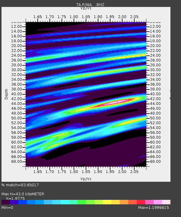
| Estimated Moho Depth: |
43.0 km |
| Estimated Crust Vp/Vs: |
1.98 |
| Assumed Crust Vp: |
6.498 km/s |
| Estimated Crust Vs: |
3.286 km/s |
| Estimated Crust Poisson's Ratio: |
0.33 |
|
| Radial Match: |
83.65017 % |
| Radial Bump: |
400 |
| Transverse Match: |
54.504246 % |
| Transverse Bump: |
400 |
| SOD ConfigId: |
424168 |
| Insert Time: |
2012-02-16 09:03:28.451 +0000 |
| GWidth: |
2.5 |
| Max Bumps: |
400 |
| Tol: |
0.001 |
|

Signal To Noise
| Channel | StoN | STA | LTA |
| TA:R36A: :BHZ:20111025T03:33:32.40002Z | 21.101486 | 2.0845944E-6 | 9.878898E-8 |
| TA:R36A: :BHN:20111025T03:33:32.40002Z | 7.612441 | 7.672868E-7 | 1.0079379E-7 |
| TA:R36A: :BHE:20111025T03:33:32.40002Z | 7.467057 | 9.3507714E-7 | 1.2522699E-7 |
| Arrivals |
| Ps | 6.8 SECOND |
| PpPs | 19 SECOND |
| PsPs/PpSs | 26 SECOND |


