You are here: Home > Network List > TA - USArray Transportable Network (new EarthScope stations) Stations List
> Station Y37A Hugo, OK, USA > Earthquake Result Viewer
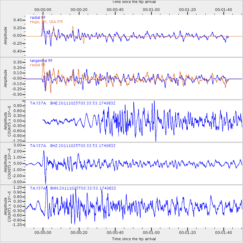
Y37A Hugo, OK, USA - Earthquake Result Viewer
*The percent match for this event was below the threshold and hence no stack was calculated.
| Earthquake location: |
Fox Islands, Aleutian Islands |
| Earthquake latitude/longitude: |
52.2/-171.8 |
| Earthquake time(UTC): |
2011/10/25 (298) 03:24:49 GMT |
| Earthquake Depth: |
38 km |
| Earthquake Magnitude: |
5.9 MB, 5.3 MS, 5.7 MW, 5.7 MW |
| Earthquake Catalog/Contributor: |
WHDF/NEIC |
|
| Network: |
TA USArray Transportable Network (new EarthScope stations) |
| Station: |
Y37A Hugo, OK, USA |
| Lat/Lon: |
33.98 N/95.62 W |
| Elevation: |
165 m |
|
| Distance: |
55.9 deg |
| Az: |
76.979 deg |
| Baz: |
313.757 deg |
| Ray Param: |
$rayparam |
*The percent match for this event was below the threshold and hence was not used in the summary stack. |
|
| Radial Match: |
73.69608 % |
| Radial Bump: |
400 |
| Transverse Match: |
70.43436 % |
| Transverse Bump: |
400 |
| SOD ConfigId: |
424168 |
| Insert Time: |
2012-02-16 09:04:49.859 +0000 |
| GWidth: |
2.5 |
| Max Bumps: |
400 |
| Tol: |
0.001 |
|
Signal To Noise
| Channel | StoN | STA | LTA |
| TA:Y37A: :BHZ:20111025T03:33:53.174983Z | 10.640945 | 1.1176453E-6 | 1.0503252E-7 |
| TA:Y37A: :BHN:20111025T03:33:53.174983Z | 4.97447 | 5.921633E-7 | 1.1904048E-7 |
| TA:Y37A: :BHE:20111025T03:33:53.174983Z | 2.5757217 | 3.6149646E-7 | 1.4034764E-7 |
| Arrivals |
| Ps | |
| PpPs | |
| PsPs/PpSs | |


