You are here: Home > Network List > TA - USArray Transportable Network (new EarthScope stations) Stations List
> Station N35A Tabor, IA, USA > Earthquake Result Viewer
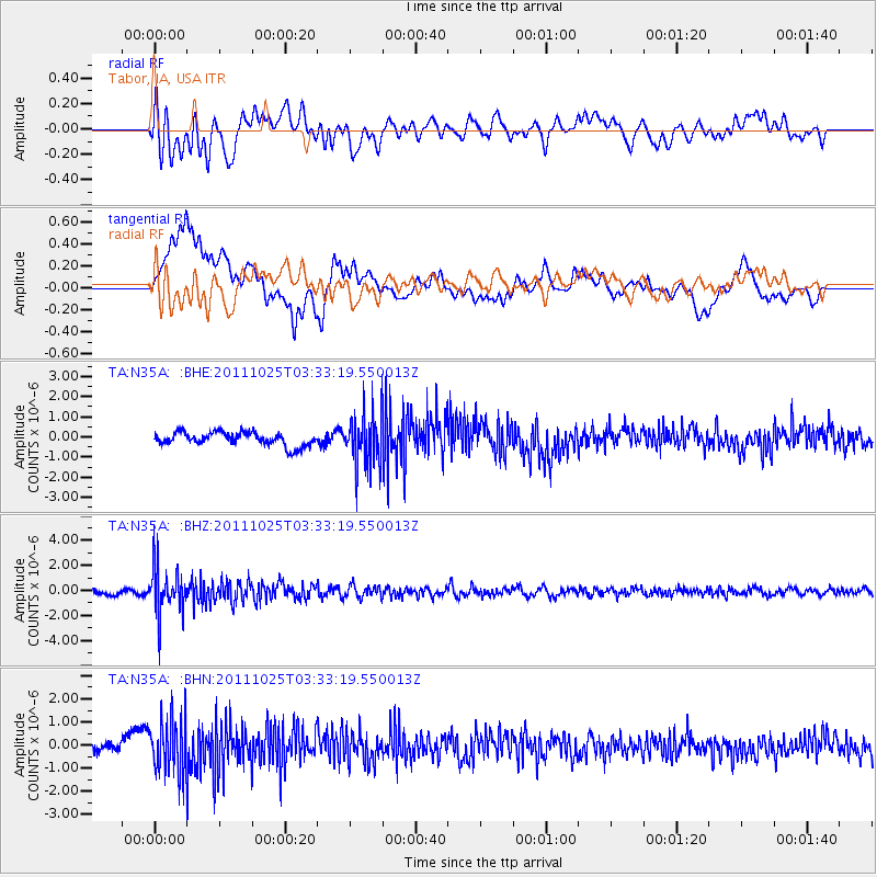
N35A Tabor, IA, USA - Earthquake Result Viewer
*The percent match for this event was below the threshold and hence no stack was calculated.
| Earthquake location: |
Fox Islands, Aleutian Islands |
| Earthquake latitude/longitude: |
52.2/-171.8 |
| Earthquake time(UTC): |
2011/10/25 (298) 03:24:49 GMT |
| Earthquake Depth: |
38 km |
| Earthquake Magnitude: |
5.9 MB, 5.3 MS, 5.7 MW, 5.7 MW |
| Earthquake Catalog/Contributor: |
WHDF/NEIC |
|
| Network: |
TA USArray Transportable Network (new EarthScope stations) |
| Station: |
N35A Tabor, IA, USA |
| Lat/Lon: |
40.86 N/95.64 W |
| Elevation: |
353 m |
|
| Distance: |
51.3 deg |
| Az: |
70.639 deg |
| Baz: |
309.978 deg |
| Ray Param: |
$rayparam |
*The percent match for this event was below the threshold and hence was not used in the summary stack. |
|
| Radial Match: |
49.56898 % |
| Radial Bump: |
400 |
| Transverse Match: |
71.73915 % |
| Transverse Bump: |
400 |
| SOD ConfigId: |
424168 |
| Insert Time: |
2012-02-16 09:05:53.932 +0000 |
| GWidth: |
2.5 |
| Max Bumps: |
400 |
| Tol: |
0.001 |
|
Signal To Noise
| Channel | StoN | STA | LTA |
| TA:N35A: :BHZ:20111025T03:33:19.550013Z | 10.004129 | 1.8643168E-6 | 1.8635473E-7 |
| TA:N35A: :BHN:20111025T03:33:19.550013Z | 4.346222 | 1.1498073E-6 | 2.6455328E-7 |
| TA:N35A: :BHE:20111025T03:33:19.550013Z | 3.911904 | 1.2930552E-6 | 3.3054368E-7 |
| Arrivals |
| Ps | |
| PpPs | |
| PsPs/PpSs | |


