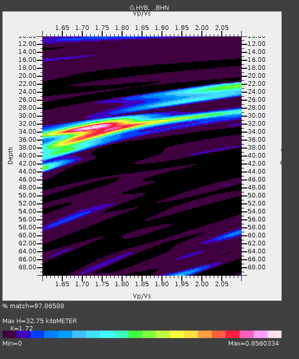
HYB Hyderabad, India - Earthquake Result Viewer

Earthquake location: Minahassa Peninsula, Sulawesi
Earthquake latitude/longitude: 1.2/122.5
Earthquake time(UTC): 1997/11/25 (329) 12:14:33 GMT
Earthquake Depth: 24 km
Earthquake Magnitude: 6.1 MB, 6.8 MS, 7.1 UNKNOWN, 6.7 ME
Earthquake Catalog/Contributor: WHDF/NEIC
Network: G GEOSCOPE
Station: HYB Hyderabad, India
Lat/Lon: 17.42 N/78.55 E
Elevation: 510 m
Distance: 46.1 deg
Az: 293.089 deg
Baz: 105.571 deg
Ray Param: 0.07080724
Estimated Moho Depth: 32.75 km
Estimated Crust Vp/Vs: 1.72
Assumed Crust Vp: 6.459 km/s
Estimated Crust Vs: 3.755 km/s
Estimated Crust Poisson's Ratio: 0.24
Radial Match: 97.86588 %
Radial Bump: 261
Transverse Match: 90.68272 %
Transverse Bump: 400
SOD ConfigId: 4480
Insert Time: 2010-02-26 22:41:12.334 +0000
GWidth: 2.5
Max Bumps: 400
Tol: 0.001

Signal To Noise

ChannelStoNSTALTA
G:HYB: :BHN:19971125T12:22:25.02099Z25.7264391.9236722E-67.4774135E-8
G:HYB: :BHE:19971125T12:22:25.02099Z4.32488062.7703587E-76.40563E-8
G:HYB: :BHZ:19971125T12:22:25.02099Z13.0120261.0001124E-67.686063E-8
Arrivals
Ps3.9 SECOND
PpPs13 SECOND
PsPs/PpSs17 SECOND