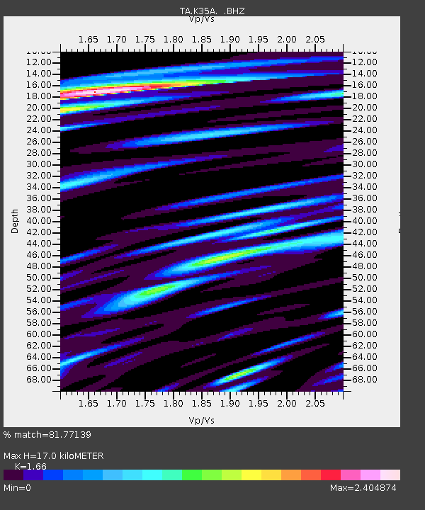
K35A Storm Lake, IA, USA - Earthquake Result Viewer
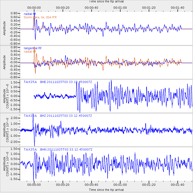
Earthquake location: Fox Islands, Aleutian Islands
Earthquake latitude/longitude: 52.2/-171.8
Earthquake time(UTC): 2011/10/25 (298) 03:24:49 GMT
Earthquake Depth: 38 km
Earthquake Magnitude: 5.9 MB, 5.3 MS, 5.7 MW, 5.7 MW
Earthquake Catalog/Contributor: WHDF/NEIC
Network: TA USArray Transportable Network (new EarthScope stations)
Station: K35A Storm Lake, IA, USA
Lat/Lon: 42.72 N/95.23 W
Elevation: 439 m
Distance: 50.4 deg
Az: 68.537 deg
Baz: 308.923 deg
Ray Param: 0.06801545
Estimated Moho Depth: 17.0 km
Estimated Crust Vp/Vs: 1.66
Assumed Crust Vp: 6.53 km/s
Estimated Crust Vs: 3.934 km/s
Estimated Crust Poisson's Ratio: 0.22
Radial Match: 81.77139 %
Radial Bump: 400
Transverse Match: 78.37033 %
Transverse Bump: 400
SOD ConfigId: 424168
Insert Time: 2012-02-16 09:10:03.575 +0000
GWidth: 2.5
Max Bumps: 400
Tol: 0.001

Signal To Noise

ChannelStoNSTALTA
TA:K35A: :BHZ:20111025T03:33:12.450007Z7.0549711.0040297E-61.423152E-7
TA:K35A: :BHN:20111025T03:33:12.450007Z4.876327.3611574E-71.5095722E-7
TA:K35A: :BHE:20111025T03:33:12.450007Z6.867769.2082837E-71.3407987E-7
Arrivals
Ps1.8 SECOND
PpPs6.5 SECOND
PsPs/PpSs8.3 SECOND