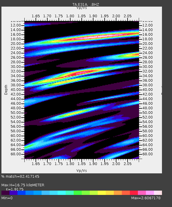
E31A Nome, ND, USA - Earthquake Result Viewer
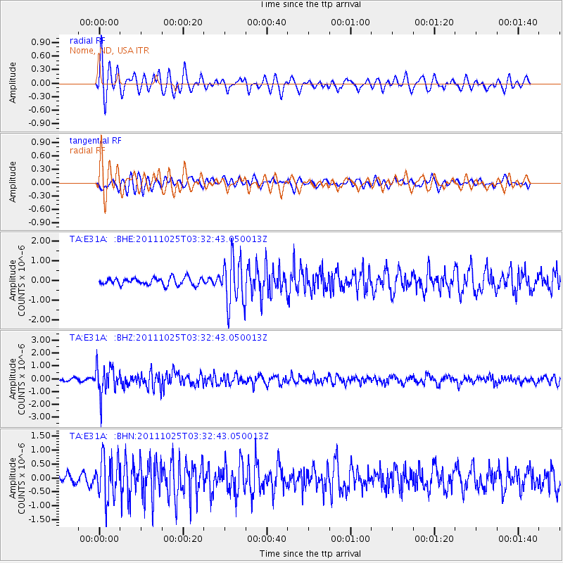
Earthquake location: Fox Islands, Aleutian Islands
Earthquake latitude/longitude: 52.2/-171.8
Earthquake time(UTC): 2011/10/25 (298) 03:24:49 GMT
Earthquake Depth: 38 km
Earthquake Magnitude: 5.9 MB, 5.3 MS, 5.7 MW, 5.7 MW
Earthquake Catalog/Contributor: WHDF/NEIC
Network: TA USArray Transportable Network (new EarthScope stations)
Station: E31A Nome, ND, USA
Lat/Lon: 46.56 N/97.89 W
Elevation: 427 m
Distance: 46.5 deg
Az: 65.983 deg
Baz: 305.367 deg
Ray Param: 0.07049512
Estimated Moho Depth: 16.75 km
Estimated Crust Vp/Vs: 1.92
Assumed Crust Vp: 6.498 km/s
Estimated Crust Vs: 3.389 km/s
Estimated Crust Poisson's Ratio: 0.31
Radial Match: 82.417145 %
Radial Bump: 396
Transverse Match: 63.719303 %
Transverse Bump: 400
SOD ConfigId: 424168
Insert Time: 2012-02-16 09:11:40.374 +0000
GWidth: 2.5
Max Bumps: 400
Tol: 0.001

Signal To Noise

ChannelStoNSTALTA
TA:E31A: :BHZ:20111025T03:32:43.050013Z9.8059411.1314337E-61.1538247E-7
TA:E31A: :BHN:20111025T03:32:43.050013Z3.84376987.614515E-71.9810018E-7
TA:E31A: :BHE:20111025T03:32:43.050013Z6.652621.2144895E-61.825581E-7
Arrivals
Ps2.5 SECOND
PpPs7.1 SECOND
PsPs/PpSs9.6 SECOND