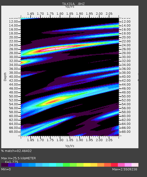
K31A O'Neill, NE, USA - Earthquake Result Viewer
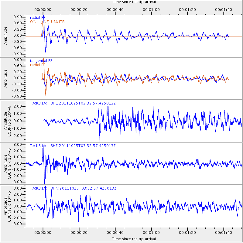
Earthquake location: Fox Islands, Aleutian Islands
Earthquake latitude/longitude: 52.2/-171.8
Earthquake time(UTC): 2011/10/25 (298) 03:24:49 GMT
Earthquake Depth: 38 km
Earthquake Magnitude: 5.9 MB, 5.3 MS, 5.7 MW, 5.7 MW
Earthquake Catalog/Contributor: WHDF/NEIC
Network: TA USArray Transportable Network (new EarthScope stations)
Station: K31A O'Neill, NE, USA
Lat/Lon: 42.62 N/98.75 W
Elevation: 580 m
Distance: 48.4 deg
Az: 70.767 deg
Baz: 307.996 deg
Ray Param: 0.06930012
Estimated Moho Depth: 25.5 km
Estimated Crust Vp/Vs: 1.77
Assumed Crust Vp: 6.53 km/s
Estimated Crust Vs: 3.679 km/s
Estimated Crust Poisson's Ratio: 0.27
Radial Match: 82.46402 %
Radial Bump: 323
Transverse Match: 81.763596 %
Transverse Bump: 400
SOD ConfigId: 424168
Insert Time: 2012-02-16 09:11:51.941 +0000
GWidth: 2.5
Max Bumps: 400
Tol: 0.001

Signal To Noise

ChannelStoNSTALTA
TA:K31A: :BHZ:20111025T03:32:57.425013Z8.3085231.2976687E-61.5618525E-7
TA:K31A: :BHN:20111025T03:32:57.425013Z5.4994181.2992031E-62.3624376E-7
TA:K31A: :BHE:20111025T03:32:57.425013Z4.5730799.728767E-72.1273998E-7
Arrivals
Ps3.2 SECOND
PpPs10 SECOND
PsPs/PpSs13 SECOND