D34A Park Rapids, MN, USA - Earthquake Result Viewer
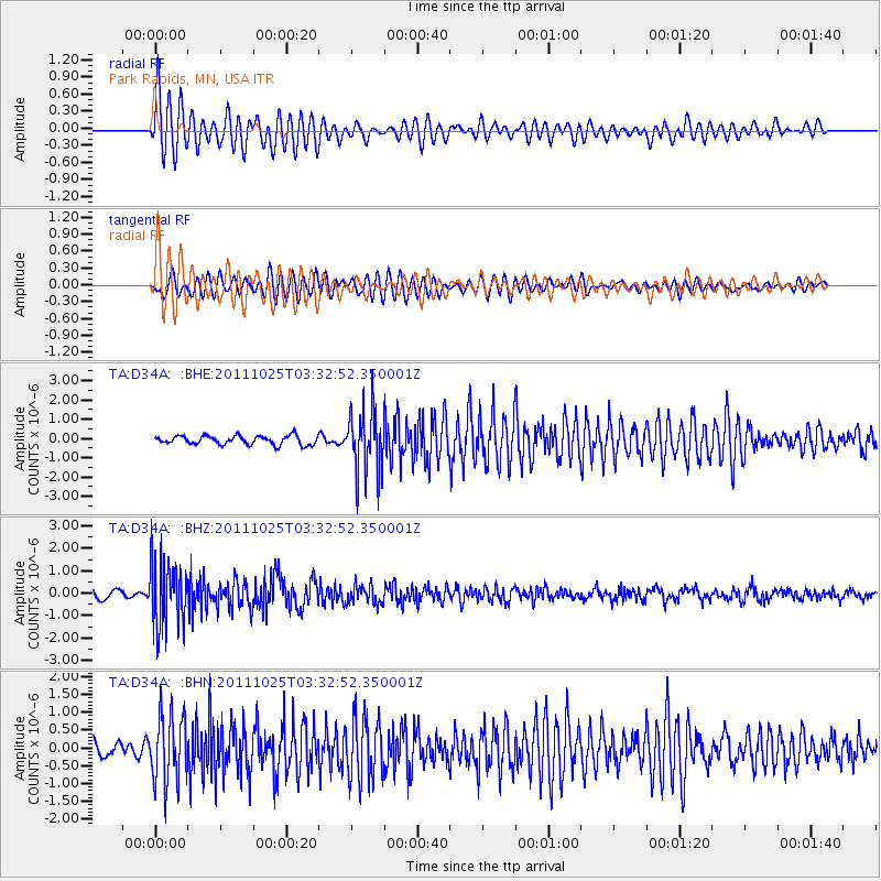
Earthquake location: Fox Islands, Aleutian Islands
Earthquake latitude/longitude: 52.2/-171.8
Earthquake time(UTC): 2011/10/25 (298) 03:24:49 GMT
Earthquake Depth: 38 km
Earthquake Magnitude: 5.9 MB, 5.3 MS, 5.7 MW, 5.7 MW
Earthquake Catalog/Contributor: WHDF/NEIC
Network: TA USArray Transportable Network (new EarthScope stations)
Station: D34A Park Rapids, MN, USA
Lat/Lon: 47.09 N/95.20 W
Elevation: 476 m
Distance: 47.7 deg
Az: 63.929 deg
Baz: 305.928 deg
Ray Param: 0.06971548
Estimated Moho Depth: 31.5 km
Estimated Crust Vp/Vs: 1.76
Assumed Crust Vp: 6.419 km/s
Estimated Crust Vs: 3.652 km/s
Estimated Crust Poisson's Ratio: 0.26
Radial Match: 81.906235 %
Radial Bump: 400
Transverse Match: 87.440025 %
Transverse Bump: 400
SOD ConfigId: 424168
Insert Time: 2012-02-16 09:12:49.005 +0000
GWidth: 2.5
Max Bumps: 400
Tol: 0.001

Signal To Noise

ChannelStoNSTALTA
TA:D34A: :BHZ:20111025T03:32:52.350001Z8.375421.4751055E-61.7612317E-7
TA:D34A: :BHN:20111025T03:32:52.350001Z6.4984229.644276E-71.484095E-7
TA:D34A: :BHE:20111025T03:32:52.350001Z7.3111771.6772254E-62.2940567E-7
Arrivals
Ps4.0 SECOND
PpPs13 SECOND
PsPs/PpSs17 SECOND