You are here: Home > Network List > TA - USArray Transportable Network (new EarthScope stations) Stations List
> Station G32A Webster, SD, USA > Earthquake Result Viewer
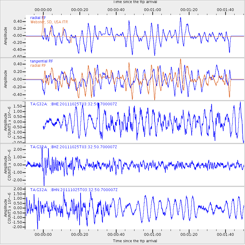
G32A Webster, SD, USA - Earthquake Result Viewer
*The percent match for this event was below the threshold and hence no stack was calculated.
| Earthquake location: |
Fox Islands, Aleutian Islands |
| Earthquake latitude/longitude: |
52.2/-171.8 |
| Earthquake time(UTC): |
2011/10/25 (298) 03:24:49 GMT |
| Earthquake Depth: |
38 km |
| Earthquake Magnitude: |
5.9 MB, 5.3 MS, 5.7 MW, 5.7 MW |
| Earthquake Catalog/Contributor: |
WHDF/NEIC |
|
| Network: |
TA USArray Transportable Network (new EarthScope stations) |
| Station: |
G32A Webster, SD, USA |
| Lat/Lon: |
45.26 N/97.50 W |
| Elevation: |
566 m |
|
| Distance: |
47.5 deg |
| Az: |
67.207 deg |
| Baz: |
306.48 deg |
| Ray Param: |
$rayparam |
*The percent match for this event was below the threshold and hence was not used in the summary stack. |
|
| Radial Match: |
57.485844 % |
| Radial Bump: |
400 |
| Transverse Match: |
58.393642 % |
| Transverse Bump: |
400 |
| SOD ConfigId: |
424168 |
| Insert Time: |
2012-02-16 09:13:28.923 +0000 |
| GWidth: |
2.5 |
| Max Bumps: |
400 |
| Tol: |
0.001 |
|
Signal To Noise
| Channel | StoN | STA | LTA |
| TA:G32A: :BHZ:20111025T03:32:50.700007Z | 5.9780145 | 1.0820198E-6 | 1.8099985E-7 |
| TA:G32A: :BHN:20111025T03:32:50.700007Z | 0.6305102 | 3.8723527E-7 | 6.1416176E-7 |
| TA:G32A: :BHE:20111025T03:32:50.700007Z | 1.5365992 | 1.0173839E-6 | 6.62101E-7 |
| Arrivals |
| Ps | |
| PpPs | |
| PsPs/PpSs | |


