You are here: Home > Network List > TA - USArray Transportable Network (new EarthScope stations) Stations List
> Station M36A Felix, Anita, IA, USA > Earthquake Result Viewer
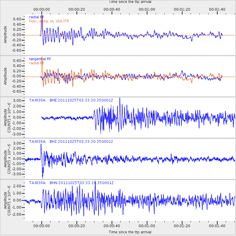
M36A Felix, Anita, IA, USA - Earthquake Result Viewer
| Earthquake location: |
Fox Islands, Aleutian Islands |
| Earthquake latitude/longitude: |
52.2/-171.8 |
| Earthquake time(UTC): |
2011/10/25 (298) 03:24:49 GMT |
| Earthquake Depth: |
38 km |
| Earthquake Magnitude: |
5.9 MB, 5.3 MS, 5.7 MW, 5.7 MW |
| Earthquake Catalog/Contributor: |
WHDF/NEIC |
|
| Network: |
TA USArray Transportable Network (new EarthScope stations) |
| Station: |
M36A Felix, Anita, IA, USA |
| Lat/Lon: |
41.45 N/94.80 W |
| Elevation: |
430 m |
|
| Distance: |
51.4 deg |
| Az: |
69.537 deg |
| Baz: |
309.841 deg |
| Ray Param: |
0.06734152 |
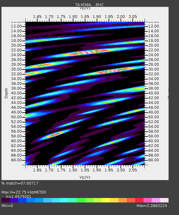
| Estimated Moho Depth: |
22.75 km |
| Estimated Crust Vp/Vs: |
1.86 |
| Assumed Crust Vp: |
6.498 km/s |
| Estimated Crust Vs: |
3.498 km/s |
| Estimated Crust Poisson's Ratio: |
0.30 |
|
| Radial Match: |
87.80717 % |
| Radial Bump: |
400 |
| Transverse Match: |
73.07887 % |
| Transverse Bump: |
400 |
| SOD ConfigId: |
424168 |
| Insert Time: |
2012-02-16 09:17:10.145 +0000 |
| GWidth: |
2.5 |
| Max Bumps: |
400 |
| Tol: |
0.001 |
|
Signal To Noise
| Channel | StoN | STA | LTA |
| TA:M36A: :BHZ:20111025T03:33:20.350001Z | 12.209044 | 1.4217505E-6 | 1.164506E-7 |
| TA:M36A: :BHN:20111025T03:33:20.350001Z | 4.9181166 | 9.021583E-7 | 1.8343573E-7 |
| TA:M36A: :BHE:20111025T03:33:20.350001Z | 8.651103 | 1.1523242E-6 | 1.3319969E-7 |
| Arrivals |
| Ps | 3.2 SECOND |
| PpPs | 9.5 SECOND |
| PsPs/PpSs | 13 SECOND |


