You are here: Home > Network List > TA - USArray Transportable Network (new EarthScope stations) Stations List
> Station J41A Loganville, WI, USA > Earthquake Result Viewer
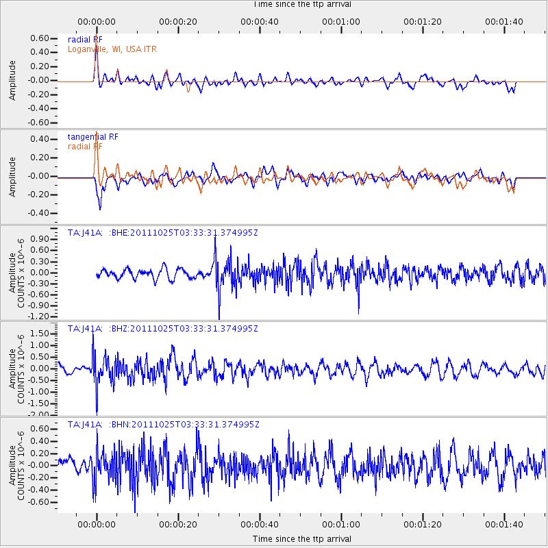
J41A Loganville, WI, USA - Earthquake Result Viewer
*The percent match for this event was below the threshold and hence no stack was calculated.
| Earthquake location: |
Fox Islands, Aleutian Islands |
| Earthquake latitude/longitude: |
52.2/-171.8 |
| Earthquake time(UTC): |
2011/10/25 (298) 03:24:49 GMT |
| Earthquake Depth: |
38 km |
| Earthquake Magnitude: |
5.9 MB, 5.3 MS, 5.7 MW, 5.7 MW |
| Earthquake Catalog/Contributor: |
WHDF/NEIC |
|
| Network: |
TA USArray Transportable Network (new EarthScope stations) |
| Station: |
J41A Loganville, WI, USA |
| Lat/Lon: |
43.37 N/90.01 W |
| Elevation: |
360 m |
|
| Distance: |
52.9 deg |
| Az: |
64.799 deg |
| Baz: |
310.153 deg |
| Ray Param: |
$rayparam |
*The percent match for this event was below the threshold and hence was not used in the summary stack. |
|
| Radial Match: |
63.338245 % |
| Radial Bump: |
400 |
| Transverse Match: |
56.658073 % |
| Transverse Bump: |
400 |
| SOD ConfigId: |
424168 |
| Insert Time: |
2012-02-16 09:27:48.317 +0000 |
| GWidth: |
2.5 |
| Max Bumps: |
400 |
| Tol: |
0.001 |
|
Signal To Noise
| Channel | StoN | STA | LTA |
| TA:J41A: :BHZ:20111025T03:33:31.374995Z | 3.5844617 | 6.734994E-7 | 1.8789417E-7 |
| TA:J41A: :BHN:20111025T03:33:31.374995Z | 1.800586 | 2.4163032E-7 | 1.3419537E-7 |
| TA:J41A: :BHE:20111025T03:33:31.374995Z | 3.5094106 | 4.4489778E-7 | 1.2677279E-7 |
| Arrivals |
| Ps | |
| PpPs | |
| PsPs/PpSs | |


