You are here: Home > Network List > TA - USArray Transportable Network (new EarthScope stations) Stations List
> Station P42A Winchester, IL, USA > Earthquake Result Viewer
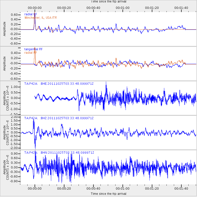
P42A Winchester, IL, USA - Earthquake Result Viewer
*The percent match for this event was below the threshold and hence no stack was calculated.
| Earthquake location: |
Fox Islands, Aleutian Islands |
| Earthquake latitude/longitude: |
52.2/-171.8 |
| Earthquake time(UTC): |
2011/10/25 (298) 03:24:49 GMT |
| Earthquake Depth: |
38 km |
| Earthquake Magnitude: |
5.9 MB, 5.3 MS, 5.7 MW, 5.7 MW |
| Earthquake Catalog/Contributor: |
WHDF/NEIC |
|
| Network: |
TA USArray Transportable Network (new EarthScope stations) |
| Station: |
P42A Winchester, IL, USA |
| Lat/Lon: |
39.59 N/90.34 W |
| Elevation: |
197 m |
|
| Distance: |
55.2 deg |
| Az: |
68.514 deg |
| Baz: |
312.116 deg |
| Ray Param: |
$rayparam |
*The percent match for this event was below the threshold and hence was not used in the summary stack. |
|
| Radial Match: |
73.331505 % |
| Radial Bump: |
400 |
| Transverse Match: |
62.250504 % |
| Transverse Bump: |
400 |
| SOD ConfigId: |
424168 |
| Insert Time: |
2012-02-16 09:28:12.814 +0000 |
| GWidth: |
2.5 |
| Max Bumps: |
400 |
| Tol: |
0.001 |
|
Signal To Noise
| Channel | StoN | STA | LTA |
| TA:P42A: :BHZ:20111025T03:33:48.099971Z | 10.701811 | 8.1972337E-7 | 7.65967E-8 |
| TA:P42A: :BHN:20111025T03:33:48.099971Z | 3.7964256 | 4.0733318E-7 | 1.0729387E-7 |
| TA:P42A: :BHE:20111025T03:33:48.099971Z | 2.972224 | 4.2617268E-7 | 1.4338511E-7 |
| Arrivals |
| Ps | |
| PpPs | |
| PsPs/PpSs | |


