You are here: Home > Network List > TA - USArray Transportable Network (new EarthScope stations) Stations List
> Station I33A Coleman, SD, USA > Earthquake Result Viewer
I33A Coleman, SD, USA - Earthquake Result Viewer
*The percent match for this event was below the threshold and hence no stack was calculated.
| Earthquake location: |
Turkey |
| Earthquake latitude/longitude: |
38.8/43.6 |
| Earthquake time(UTC): |
2011/10/25 (298) 14:55:08 GMT |
| Earthquake Depth: |
14 km |
| Earthquake Magnitude: |
5.7 MB, 5.2 MS, 5.6 MW, 5.3 MW |
| Earthquake Catalog/Contributor: |
WHDF/NEIC |
|
| Network: |
TA USArray Transportable Network (new EarthScope stations) |
| Station: |
I33A Coleman, SD, USA |
| Lat/Lon: |
44.05 N/96.80 W |
| Elevation: |
509 m |
|
| Distance: |
90.1 deg |
| Az: |
332.65 deg |
| Baz: |
29.853 deg |
| Ray Param: |
$rayparam |
*The percent match for this event was below the threshold and hence was not used in the summary stack. |
|
| Radial Match: |
63.12969 % |
| Radial Bump: |
400 |
| Transverse Match: |
52.561794 % |
| Transverse Bump: |
400 |
| SOD ConfigId: |
424168 |
| Insert Time: |
2012-02-16 09:48:28.930 +0000 |
| GWidth: |
2.5 |
| Max Bumps: |
400 |
| Tol: |
0.001 |
|
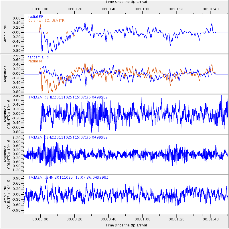
Signal To Noise
| Channel | StoN | STA | LTA |
| TA:I33A: :BHZ:20111025T15:07:36.049998Z | 2.4411333 | 4.8696955E-7 | 1.9948503E-7 |
| TA:I33A: :BHN:20111025T15:07:36.049998Z | 2.150826 | 4.0424698E-7 | 1.8794965E-7 |
| TA:I33A: :BHE:20111025T15:07:36.049998Z | 1.4841431 | 3.3841852E-7 | 2.2802283E-7 |
| Arrivals |
| Ps | |
| PpPs | |
| PsPs/PpSs | |


