You are here: Home > Network List > TA - USArray Transportable Network (new EarthScope stations) Stations List
> Station C33A Trail, MN, USA > Earthquake Result Viewer
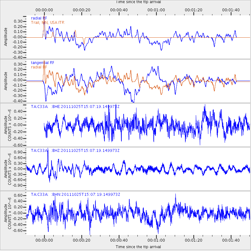
C33A Trail, MN, USA - Earthquake Result Viewer
*The percent match for this event was below the threshold and hence no stack was calculated.
| Earthquake location: |
Turkey |
| Earthquake latitude/longitude: |
38.8/43.6 |
| Earthquake time(UTC): |
2011/10/25 (298) 14:55:08 GMT |
| Earthquake Depth: |
14 km |
| Earthquake Magnitude: |
5.7 MB, 5.2 MS, 5.6 MW, 5.3 MW |
| Earthquake Catalog/Contributor: |
WHDF/NEIC |
|
| Network: |
TA USArray Transportable Network (new EarthScope stations) |
| Station: |
C33A Trail, MN, USA |
| Lat/Lon: |
47.76 N/95.77 W |
| Elevation: |
388 m |
|
| Distance: |
86.5 deg |
| Az: |
333.9 deg |
| Baz: |
30.624 deg |
| Ray Param: |
$rayparam |
*The percent match for this event was below the threshold and hence was not used in the summary stack. |
|
| Radial Match: |
50.520416 % |
| Radial Bump: |
400 |
| Transverse Match: |
61.383087 % |
| Transverse Bump: |
400 |
| SOD ConfigId: |
424168 |
| Insert Time: |
2012-02-16 09:49:20.679 +0000 |
| GWidth: |
2.5 |
| Max Bumps: |
400 |
| Tol: |
0.001 |
|
Signal To Noise
| Channel | StoN | STA | LTA |
| TA:C33A: :BHZ:20111025T15:07:19.149973Z | 3.2304893 | 3.4477117E-7 | 1.0672413E-7 |
| TA:C33A: :BHN:20111025T15:07:19.149973Z | 1.8291799 | 2.1785019E-7 | 1.1909719E-7 |
| TA:C33A: :BHE:20111025T15:07:19.149973Z | 1.4124793 | 1.9561301E-7 | 1.3848911E-7 |
| Arrivals |
| Ps | |
| PpPs | |
| PsPs/PpSs | |


