You are here: Home > Network List > TA - USArray Transportable Network (new EarthScope stations) Stations List
> Station R42A Luebbering, MO, USA > Earthquake Result Viewer
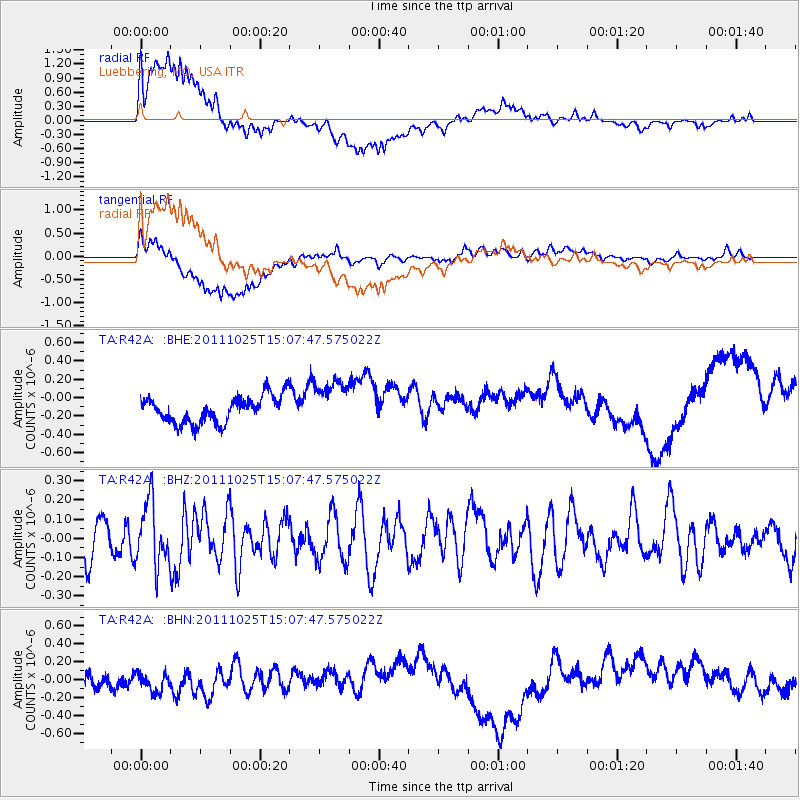
R42A Luebbering, MO, USA - Earthquake Result Viewer
*The percent match for this event was below the threshold and hence no stack was calculated.
| Earthquake location: |
Turkey |
| Earthquake latitude/longitude: |
38.8/43.6 |
| Earthquake time(UTC): |
2011/10/25 (298) 14:55:08 GMT |
| Earthquake Depth: |
14 km |
| Earthquake Magnitude: |
5.7 MB, 5.2 MS, 5.6 MW, 5.3 MW |
| Earthquake Catalog/Contributor: |
WHDF/NEIC |
|
| Network: |
TA USArray Transportable Network (new EarthScope stations) |
| Station: |
R42A Luebbering, MO, USA |
| Lat/Lon: |
38.28 N/90.79 W |
| Elevation: |
218 m |
|
| Distance: |
92.6 deg |
| Az: |
325.757 deg |
| Baz: |
33.959 deg |
| Ray Param: |
$rayparam |
*The percent match for this event was below the threshold and hence was not used in the summary stack. |
|
| Radial Match: |
68.72836 % |
| Radial Bump: |
400 |
| Transverse Match: |
55.39957 % |
| Transverse Bump: |
400 |
| SOD ConfigId: |
424168 |
| Insert Time: |
2012-02-16 09:54:12.997 +0000 |
| GWidth: |
2.5 |
| Max Bumps: |
400 |
| Tol: |
0.001 |
|
Signal To Noise
| Channel | StoN | STA | LTA |
| TA:R42A: :BHZ:20111025T15:07:47.575022Z | 1.7035868 | 1.6284673E-7 | 9.5590515E-8 |
| TA:R42A: :BHN:20111025T15:07:47.575022Z | 1.1369387 | 1.05934745E-7 | 9.317542E-8 |
| TA:R42A: :BHE:20111025T15:07:47.575022Z | 1.7574528 | 2.5479346E-7 | 1.4497884E-7 |
| Arrivals |
| Ps | |
| PpPs | |
| PsPs/PpSs | |


