You are here: Home > Network List > TA - USArray Transportable Network (new EarthScope stations) Stations List
> Station G42A Mountain, WI, USA > Earthquake Result Viewer
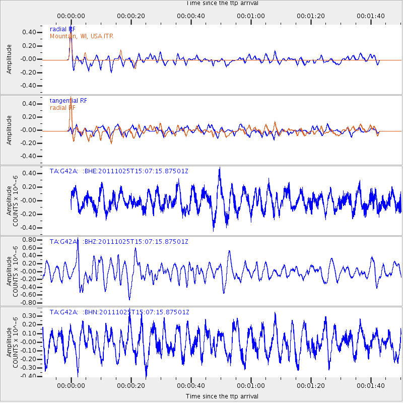
G42A Mountain, WI, USA - Earthquake Result Viewer
*The percent match for this event was below the threshold and hence no stack was calculated.
| Earthquake location: |
Turkey |
| Earthquake latitude/longitude: |
38.8/43.6 |
| Earthquake time(UTC): |
2011/10/25 (298) 14:55:08 GMT |
| Earthquake Depth: |
14 km |
| Earthquake Magnitude: |
5.7 MB, 5.2 MS, 5.6 MW, 5.3 MW |
| Earthquake Catalog/Contributor: |
WHDF/NEIC |
|
| Network: |
TA USArray Transportable Network (new EarthScope stations) |
| Station: |
G42A Mountain, WI, USA |
| Lat/Lon: |
45.24 N/88.43 W |
| Elevation: |
315 m |
|
| Distance: |
85.9 deg |
| Az: |
328.266 deg |
| Baz: |
35.566 deg |
| Ray Param: |
$rayparam |
*The percent match for this event was below the threshold and hence was not used in the summary stack. |
|
| Radial Match: |
63.848812 % |
| Radial Bump: |
400 |
| Transverse Match: |
44.514935 % |
| Transverse Bump: |
400 |
| SOD ConfigId: |
424168 |
| Insert Time: |
2012-02-16 09:57:04.228 +0000 |
| GWidth: |
2.5 |
| Max Bumps: |
400 |
| Tol: |
0.001 |
|
Signal To Noise
| Channel | StoN | STA | LTA |
| TA:G42A: :BHZ:20111025T15:07:15.87501Z | 2.6162035 | 3.3422938E-7 | 1.277536E-7 |
| TA:G42A: :BHN:20111025T15:07:15.87501Z | 1.3174767 | 1.5368143E-7 | 1.1664831E-7 |
| TA:G42A: :BHE:20111025T15:07:15.87501Z | 0.7326249 | 7.862283E-8 | 1.0731663E-7 |
| Arrivals |
| Ps | |
| PpPs | |
| PsPs/PpSs | |


