You are here: Home > Network List > AZ - ANZA Regional Network Stations List
> Station SMER AZ.SMER > Earthquake Result Viewer
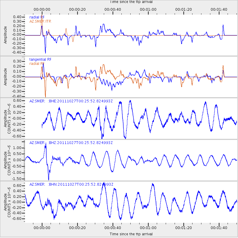
SMER AZ.SMER - Earthquake Result Viewer
*The percent match for this event was below the threshold and hence no stack was calculated.
| Earthquake location: |
Fiji Islands Region |
| Earthquake latitude/longitude: |
-17.9/-179.5 |
| Earthquake time(UTC): |
2011/10/27 (300) 00:15:24 GMT |
| Earthquake Depth: |
603 km |
| Earthquake Magnitude: |
6.0 MW, 5.3 MB, 6.0 MW |
| Earthquake Catalog/Contributor: |
WHDF/NEIC |
|
| Network: |
AZ ANZA Regional Network |
| Station: |
SMER AZ.SMER |
| Lat/Lon: |
33.46 N/117.17 W |
| Elevation: |
355 m |
|
| Distance: |
78.4 deg |
| Az: |
49.117 deg |
| Baz: |
239.423 deg |
| Ray Param: |
$rayparam |
*The percent match for this event was below the threshold and hence was not used in the summary stack. |
|
| Radial Match: |
77.03337 % |
| Radial Bump: |
400 |
| Transverse Match: |
44.107533 % |
| Transverse Bump: |
400 |
| SOD ConfigId: |
424168 |
| Insert Time: |
2012-02-16 10:05:34.989 +0000 |
| GWidth: |
2.5 |
| Max Bumps: |
400 |
| Tol: |
0.001 |
|
Signal To Noise
| Channel | StoN | STA | LTA |
| AZ:SMER: :BHZ:20111027T00:25:52.824993Z | 2.9109764 | 7.516051E-7 | 2.581969E-7 |
| AZ:SMER: :BHN:20111027T00:25:52.824993Z | 0.97579986 | 1.4302574E-7 | 1.4657283E-7 |
| AZ:SMER: :BHE:20111027T00:25:52.824993Z | 1.9310524 | 3.3952017E-7 | 1.7582131E-7 |
| Arrivals |
| Ps | |
| PpPs | |
| PsPs/PpSs | |


