You are here: Home > Network List > CI - Caltech Regional Seismic Network Stations List
> Station TUQ Turquiose Mountain, Baker, CA, USA > Earthquake Result Viewer
TUQ Turquiose Mountain, Baker, CA, USA - Earthquake Result Viewer
*The percent match for this event was below the threshold and hence no stack was calculated.
| Earthquake location: |
Fiji Islands Region |
| Earthquake latitude/longitude: |
-17.9/-179.5 |
| Earthquake time(UTC): |
2011/10/27 (300) 00:15:24 GMT |
| Earthquake Depth: |
603 km |
| Earthquake Magnitude: |
6.0 MW, 5.3 MB, 6.0 MW |
| Earthquake Catalog/Contributor: |
WHDF/NEIC |
|
| Network: |
CI Caltech Regional Seismic Network |
| Station: |
TUQ Turquiose Mountain, Baker, CA, USA |
| Lat/Lon: |
35.44 N/115.92 W |
| Elevation: |
1350 m |
|
| Distance: |
80.3 deg |
| Az: |
47.914 deg |
| Baz: |
239.902 deg |
| Ray Param: |
$rayparam |
*The percent match for this event was below the threshold and hence was not used in the summary stack. |
|
| Radial Match: |
54.881454 % |
| Radial Bump: |
400 |
| Transverse Match: |
53.934418 % |
| Transverse Bump: |
400 |
| SOD ConfigId: |
424168 |
| Insert Time: |
2012-02-16 10:07:55.652 +0000 |
| GWidth: |
2.5 |
| Max Bumps: |
400 |
| Tol: |
0.001 |
|
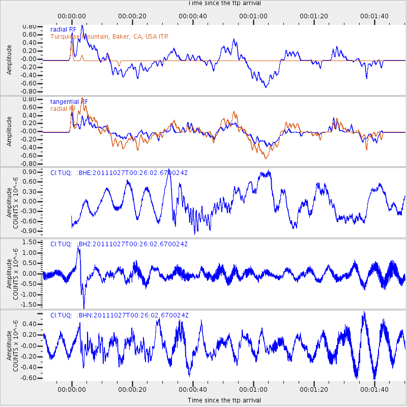
Signal To Noise
| Channel | StoN | STA | LTA |
| CI:TUQ: :BHZ:20111027T00:26:02.670024Z | 4.2370152 | 7.4902147E-7 | 1.7678045E-7 |
| CI:TUQ: :BHN:20111027T00:26:02.670024Z | 1.0990603 | 1.9814642E-7 | 1.8028713E-7 |
| CI:TUQ: :BHE:20111027T00:26:02.670024Z | 1.6321647 | 5.624023E-7 | 3.445745E-7 |
| Arrivals |
| Ps | |
| PpPs | |
| PsPs/PpSs | |


