You are here: Home > Network List > TA - USArray Transportable Network (new EarthScope stations) Stations List
> Station G05D Wamic, OR, USA > Earthquake Result Viewer
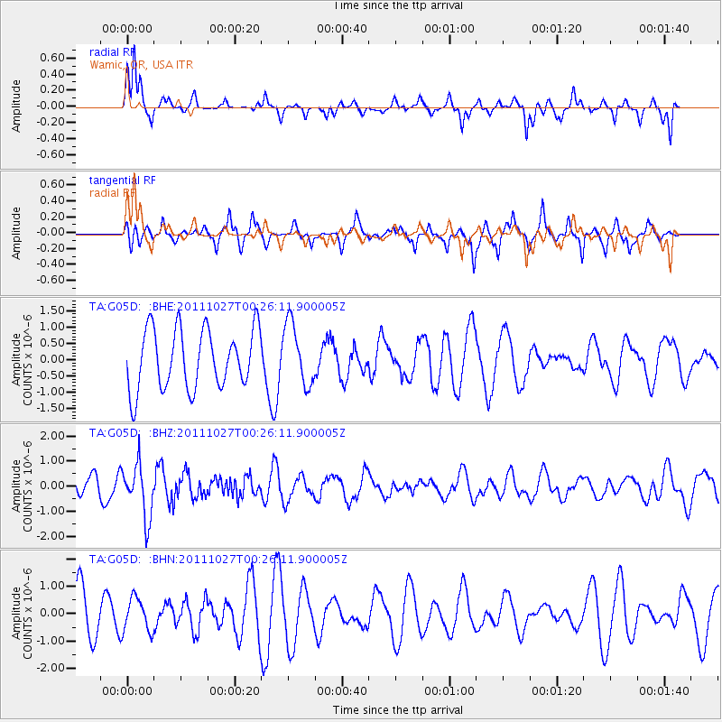
G05D Wamic, OR, USA - Earthquake Result Viewer
*The percent match for this event was below the threshold and hence no stack was calculated.
| Earthquake location: |
Fiji Islands Region |
| Earthquake latitude/longitude: |
-17.9/-179.5 |
| Earthquake time(UTC): |
2011/10/27 (300) 00:15:24 GMT |
| Earthquake Depth: |
603 km |
| Earthquake Magnitude: |
6.0 MW, 5.3 MB, 6.0 MW |
| Earthquake Catalog/Contributor: |
WHDF/NEIC |
|
| Network: |
TA USArray Transportable Network (new EarthScope stations) |
| Station: |
G05D Wamic, OR, USA |
| Lat/Lon: |
45.24 N/121.32 W |
| Elevation: |
592 m |
|
| Distance: |
82.1 deg |
| Az: |
37.323 deg |
| Baz: |
234.783 deg |
| Ray Param: |
$rayparam |
*The percent match for this event was below the threshold and hence was not used in the summary stack. |
|
| Radial Match: |
55.45642 % |
| Radial Bump: |
322 |
| Transverse Match: |
39.557762 % |
| Transverse Bump: |
273 |
| SOD ConfigId: |
424168 |
| Insert Time: |
2012-02-16 10:12:21.937 +0000 |
| GWidth: |
2.5 |
| Max Bumps: |
400 |
| Tol: |
0.001 |
|
Signal To Noise
| Channel | StoN | STA | LTA |
| TA:G05D: :BHZ:20111027T00:26:11.900005Z | 3.1934907 | 1.0512578E-6 | 3.2918763E-7 |
| TA:G05D: :BHN:20111027T00:26:11.900005Z | 0.6747263 | 6.0495773E-7 | 8.9659716E-7 |
| TA:G05D: :BHE:20111027T00:26:11.900005Z | 1.040656 | 9.4889333E-7 | 9.118223E-7 |
| Arrivals |
| Ps | |
| PpPs | |
| PsPs/PpSs | |


