You are here: Home > Network List > TA - USArray Transportable Network (new EarthScope stations) Stations List
> Station W36A Wetumka, OK, USA > Earthquake Result Viewer
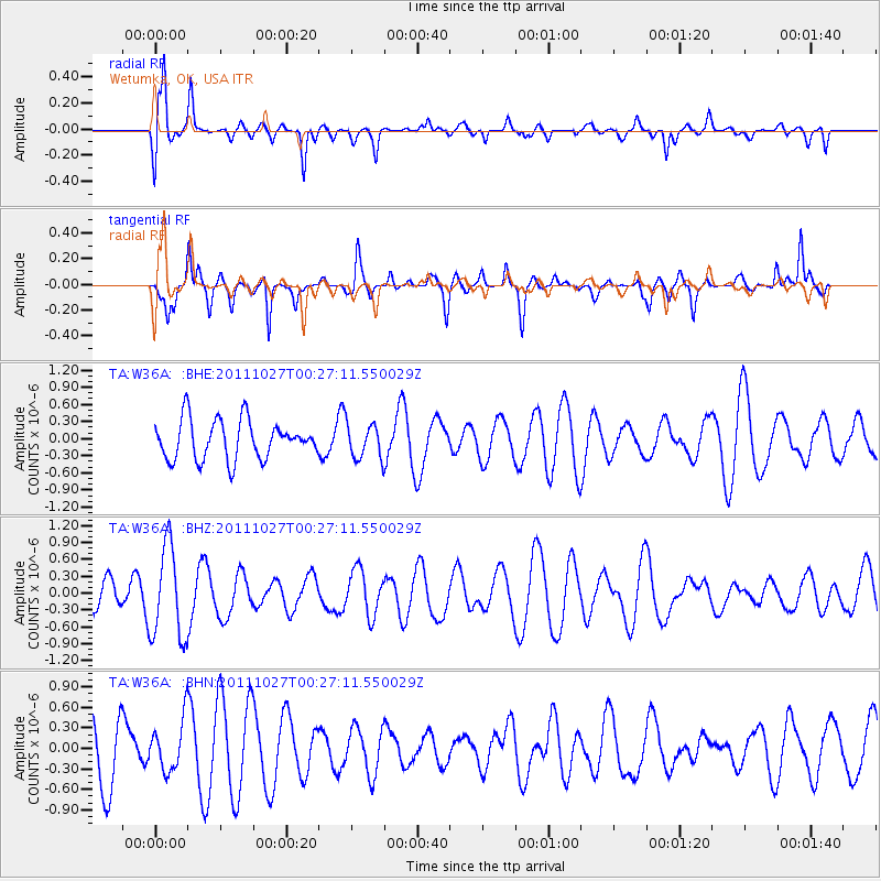
W36A Wetumka, OK, USA - Earthquake Result Viewer
*The percent match for this event was below the threshold and hence no stack was calculated.
| Earthquake location: |
Fiji Islands Region |
| Earthquake latitude/longitude: |
-17.9/-179.5 |
| Earthquake time(UTC): |
2011/10/27 (300) 00:15:24 GMT |
| Earthquake Depth: |
603 km |
| Earthquake Magnitude: |
6.0 MW, 5.3 MB, 6.0 MW |
| Earthquake Catalog/Contributor: |
WHDF/NEIC |
|
| Network: |
TA USArray Transportable Network (new EarthScope stations) |
| Station: |
W36A Wetumka, OK, USA |
| Lat/Lon: |
35.14 N/96.23 W |
| Elevation: |
251 m |
|
| Distance: |
94.8 deg |
| Az: |
54.775 deg |
| Baz: |
251.6 deg |
| Ray Param: |
$rayparam |
*The percent match for this event was below the threshold and hence was not used in the summary stack. |
|
| Radial Match: |
69.38619 % |
| Radial Bump: |
400 |
| Transverse Match: |
63.837627 % |
| Transverse Bump: |
316 |
| SOD ConfigId: |
424168 |
| Insert Time: |
2012-02-16 10:13:41.075 +0000 |
| GWidth: |
2.5 |
| Max Bumps: |
400 |
| Tol: |
0.001 |
|
Signal To Noise
| Channel | StoN | STA | LTA |
| TA:W36A: :BHZ:20111027T00:27:11.550029Z | 2.3012793 | 8.202706E-7 | 3.5644112E-7 |
| TA:W36A: :BHN:20111027T00:27:11.550029Z | 0.8690377 | 3.6282566E-7 | 4.1750278E-7 |
| TA:W36A: :BHE:20111027T00:27:11.550029Z | 0.8825134 | 2.993169E-7 | 3.3916413E-7 |
| Arrivals |
| Ps | |
| PpPs | |
| PsPs/PpSs | |


