You are here: Home > Network List > TA - USArray Transportable Network (new EarthScope stations) Stations List
> Station L04D Klamath Falls, OR, USA > Earthquake Result Viewer
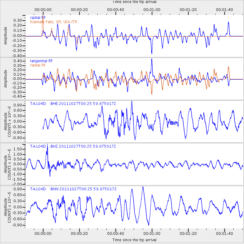
L04D Klamath Falls, OR, USA - Earthquake Result Viewer
*The percent match for this event was below the threshold and hence no stack was calculated.
| Earthquake location: |
Fiji Islands Region |
| Earthquake latitude/longitude: |
-17.9/-179.5 |
| Earthquake time(UTC): |
2011/10/27 (300) 00:15:24 GMT |
| Earthquake Depth: |
603 km |
| Earthquake Magnitude: |
6.0 MW, 5.3 MB, 6.0 MW |
| Earthquake Catalog/Contributor: |
WHDF/NEIC |
|
| Network: |
TA USArray Transportable Network (new EarthScope stations) |
| Station: |
L04D Klamath Falls, OR, USA |
| Lat/Lon: |
42.22 N/122.30 W |
| Elevation: |
1437 m |
|
| Distance: |
79.8 deg |
| Az: |
39.398 deg |
| Baz: |
234.43 deg |
| Ray Param: |
$rayparam |
*The percent match for this event was below the threshold and hence was not used in the summary stack. |
|
| Radial Match: |
49.84857 % |
| Radial Bump: |
400 |
| Transverse Match: |
44.037952 % |
| Transverse Bump: |
370 |
| SOD ConfigId: |
424168 |
| Insert Time: |
2012-02-16 10:14:08.881 +0000 |
| GWidth: |
2.5 |
| Max Bumps: |
400 |
| Tol: |
0.001 |
|
Signal To Noise
| Channel | StoN | STA | LTA |
| TA:L04D: :BHZ:20111027T00:25:59.975017Z | 2.744511 | 6.754612E-7 | 2.461135E-7 |
| TA:L04D: :BHN:20111027T00:25:59.975017Z | 0.7424292 | 2.1674181E-7 | 2.91936E-7 |
| TA:L04D: :BHE:20111027T00:25:59.975017Z | 1.8555744 | 4.6630925E-7 | 2.5130183E-7 |
| Arrivals |
| Ps | |
| PpPs | |
| PsPs/PpSs | |


