You are here: Home > Network List > UW - Pacific Northwest Regional Seismic Network Stations List
> Station LEBA Lebam, WA, USA > Earthquake Result Viewer
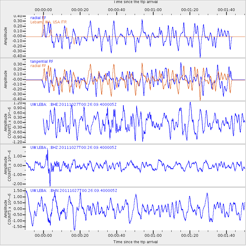
LEBA Lebam, WA, USA - Earthquake Result Viewer
*The percent match for this event was below the threshold and hence no stack was calculated.
| Earthquake location: |
Fiji Islands Region |
| Earthquake latitude/longitude: |
-17.9/-179.5 |
| Earthquake time(UTC): |
2011/10/27 (300) 00:15:24 GMT |
| Earthquake Depth: |
603 km |
| Earthquake Magnitude: |
6.0 MW, 5.3 MB, 6.0 MW |
| Earthquake Catalog/Contributor: |
WHDF/NEIC |
|
| Network: |
UW Pacific Northwest Regional Seismic Network |
| Station: |
LEBA Lebam, WA, USA |
| Lat/Lon: |
46.55 N/123.56 W |
| Elevation: |
73 m |
|
| Distance: |
81.6 deg |
| Az: |
35.324 deg |
| Baz: |
232.891 deg |
| Ray Param: |
$rayparam |
*The percent match for this event was below the threshold and hence was not used in the summary stack. |
|
| Radial Match: |
55.628284 % |
| Radial Bump: |
400 |
| Transverse Match: |
47.20384 % |
| Transverse Bump: |
400 |
| SOD ConfigId: |
424168 |
| Insert Time: |
2012-02-16 10:15:57.474 +0000 |
| GWidth: |
2.5 |
| Max Bumps: |
400 |
| Tol: |
0.001 |
|
Signal To Noise
| Channel | StoN | STA | LTA |
| UW:LEBA: :BHZ:20111027T00:26:09.400005Z | 2.5186698 | 7.95146E-7 | 3.157008E-7 |
| UW:LEBA: :BHN:20111027T00:26:09.400005Z | 0.8876265 | 6.1988106E-7 | 6.98358E-7 |
| UW:LEBA: :BHE:20111027T00:26:09.400005Z | 0.899108 | 4.2283273E-7 | 4.7028027E-7 |
| Arrivals |
| Ps | |
| PpPs | |
| PsPs/PpSs | |


