You are here: Home > Network List > CI - Caltech Regional Seismic Network Stations List
> Station DEC Green Verdugo Microwave Site, Sunland, CA, USA > Earthquake Result Viewer
DEC Green Verdugo Microwave Site, Sunland, CA, USA - Earthquake Result Viewer
| Earthquake location: |
Near Coast Of Peru |
| Earthquake latitude/longitude: |
-14.4/-76.0 |
| Earthquake time(UTC): |
2011/10/28 (301) 18:54:34 GMT |
| Earthquake Depth: |
24 km |
| Earthquake Magnitude: |
6.5 MB, 6.9 MS, 6.9 MW, 6.9 MW |
| Earthquake Catalog/Contributor: |
WHDF/NEIC |
|
| Network: |
CI Caltech Regional Seismic Network |
| Station: |
DEC Green Verdugo Microwave Site, Sunland, CA, USA |
| Lat/Lon: |
34.25 N/118.33 W |
| Elevation: |
519 m |
|
| Distance: |
63.0 deg |
| Az: |
321.208 deg |
| Baz: |
132.88 deg |
| Ray Param: |
0.059832927 |
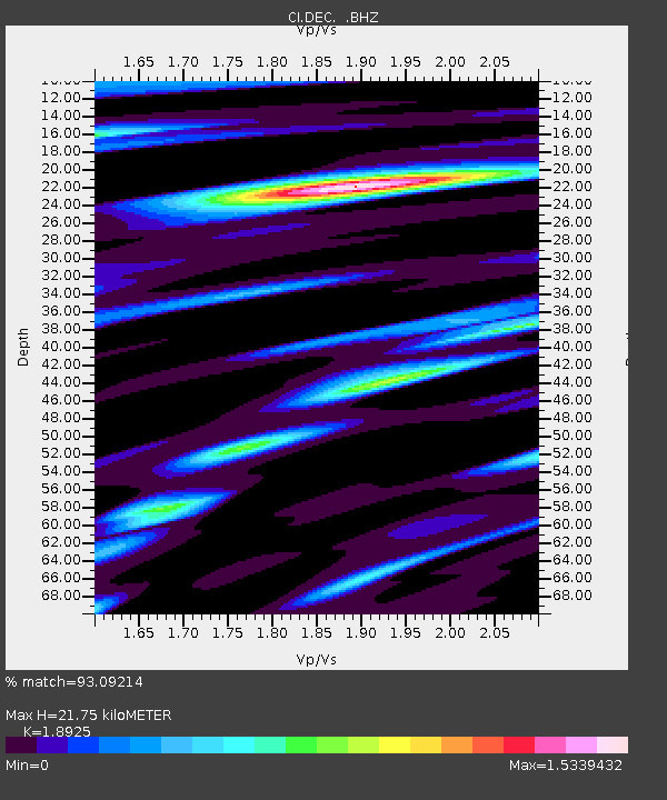
| Estimated Moho Depth: |
21.75 km |
| Estimated Crust Vp/Vs: |
1.89 |
| Assumed Crust Vp: |
6.1 km/s |
| Estimated Crust Vs: |
3.223 km/s |
| Estimated Crust Poisson's Ratio: |
0.31 |
|
| Radial Match: |
93.09214 % |
| Radial Bump: |
400 |
| Transverse Match: |
86.686646 % |
| Transverse Bump: |
400 |
| SOD ConfigId: |
424168 |
| Insert Time: |
2012-02-16 10:33:39.371 +0000 |
| GWidth: |
2.5 |
| Max Bumps: |
400 |
| Tol: |
0.001 |
|

Signal To Noise
| Channel | StoN | STA | LTA |
| CI:DEC: :BHZ:20111028T19:04:27.76998Z | 3.760502 | 9.058071E-7 | 2.4087396E-7 |
| CI:DEC: :BHN:20111028T19:04:27.76998Z | 0.85873103 | 3.5081692E-7 | 4.0852944E-7 |
| CI:DEC: :BHE:20111028T19:04:27.76998Z | 1.0339644 | 5.25239E-7 | 5.079856E-7 |
| Arrivals |
| Ps | 3.3 SECOND |
| PpPs | 9.9 SECOND |
| PsPs/PpSs | 13 SECOND |


