You are here: Home > Network List > G - GEOSCOPE Stations List
> Station HYB Hyderabad, India > Earthquake Result Viewer
HYB Hyderabad, India - Earthquake Result Viewer
| Earthquake location: |
Solomon Islands |
| Earthquake latitude/longitude: |
-10.5/160.8 |
| Earthquake time(UTC): |
2003/01/20 (020) 08:43:06 GMT |
| Earthquake Depth: |
33 km |
| Earthquake Magnitude: |
6.7 MB, 7.8 MS, 7.3 MW, 7.2 MW |
| Earthquake Catalog/Contributor: |
WHDF/NEIC |
|
| Network: |
G GEOSCOPE |
| Station: |
HYB Hyderabad, India |
| Lat/Lon: |
17.42 N/78.55 E |
| Elevation: |
510 m |
|
| Distance: |
85.8 deg |
| Az: |
288.471 deg |
| Baz: |
102.293 deg |
| Ray Param: |
0.04446638 |
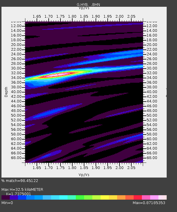
| Estimated Moho Depth: |
32.5 km |
| Estimated Crust Vp/Vs: |
1.74 |
| Assumed Crust Vp: |
6.459 km/s |
| Estimated Crust Vs: |
3.718 km/s |
| Estimated Crust Poisson's Ratio: |
0.25 |
|
| Radial Match: |
98.45122 % |
| Radial Bump: |
298 |
| Transverse Match: |
89.41267 % |
| Transverse Bump: |
400 |
| SOD ConfigId: |
4714 |
| Insert Time: |
2010-02-26 22:43:20.465 +0000 |
| GWidth: |
2.5 |
| Max Bumps: |
400 |
| Tol: |
0.001 |
|

Signal To Noise
| Channel | StoN | STA | LTA |
| G:HYB: :BHN:20030120T08:55:10.900017Z | 9.627378 | 5.70394E-7 | 5.924707E-8 |
| G:HYB: :BHE:20030120T08:55:10.900017Z | 66.67108 | 3.3665294E-6 | 5.04946E-8 |
| G:HYB: :BHZ:20030120T08:55:10.900017Z | 98.73949 | 1.06679345E-5 | 1.0804123E-7 |
| Arrivals |
| Ps | 3.8 SECOND |
| PpPs | 13 SECOND |
| PsPs/PpSs | 17 SECOND |


