You are here: Home > Network List > GT - Global Telemetered Seismograph Network (USAF/USGS) Stations List
> Station DBIC Dimbokro, Cote d'Ivoire > Earthquake Result Viewer
DBIC Dimbokro, Cote d'Ivoire - Earthquake Result Viewer
| Earthquake location: |
Near Coast Of Peru |
| Earthquake latitude/longitude: |
-14.4/-76.0 |
| Earthquake time(UTC): |
2011/10/28 (301) 18:54:34 GMT |
| Earthquake Depth: |
24 km |
| Earthquake Magnitude: |
6.5 MB, 6.9 MS, 6.9 MW, 6.9 MW |
| Earthquake Catalog/Contributor: |
WHDF/NEIC |
|
| Network: |
GT Global Telemetered Seismograph Network (USAF/USGS) |
| Station: |
DBIC Dimbokro, Cote d'Ivoire |
| Lat/Lon: |
6.67 N/4.86 W |
| Elevation: |
125 m |
|
| Distance: |
73.6 deg |
| Az: |
78.485 deg |
| Baz: |
252.882 deg |
| Ray Param: |
0.05289343 |
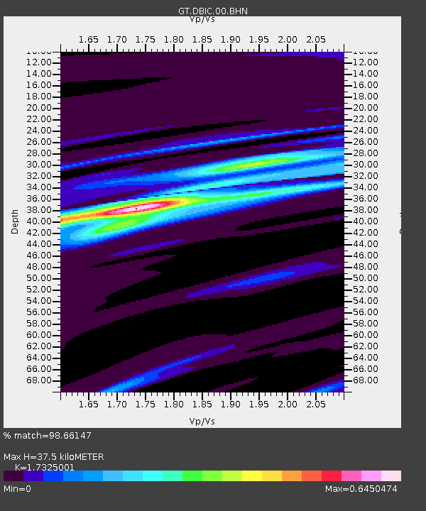
| Estimated Moho Depth: |
37.5 km |
| Estimated Crust Vp/Vs: |
1.73 |
| Assumed Crust Vp: |
6.419 km/s |
| Estimated Crust Vs: |
3.705 km/s |
| Estimated Crust Poisson's Ratio: |
0.25 |
|
| Radial Match: |
98.66147 % |
| Radial Bump: |
226 |
| Transverse Match: |
95.65776 % |
| Transverse Bump: |
400 |
| SOD ConfigId: |
424168 |
| Insert Time: |
2012-02-16 10:36:22.283 +0000 |
| GWidth: |
2.5 |
| Max Bumps: |
400 |
| Tol: |
0.001 |
|
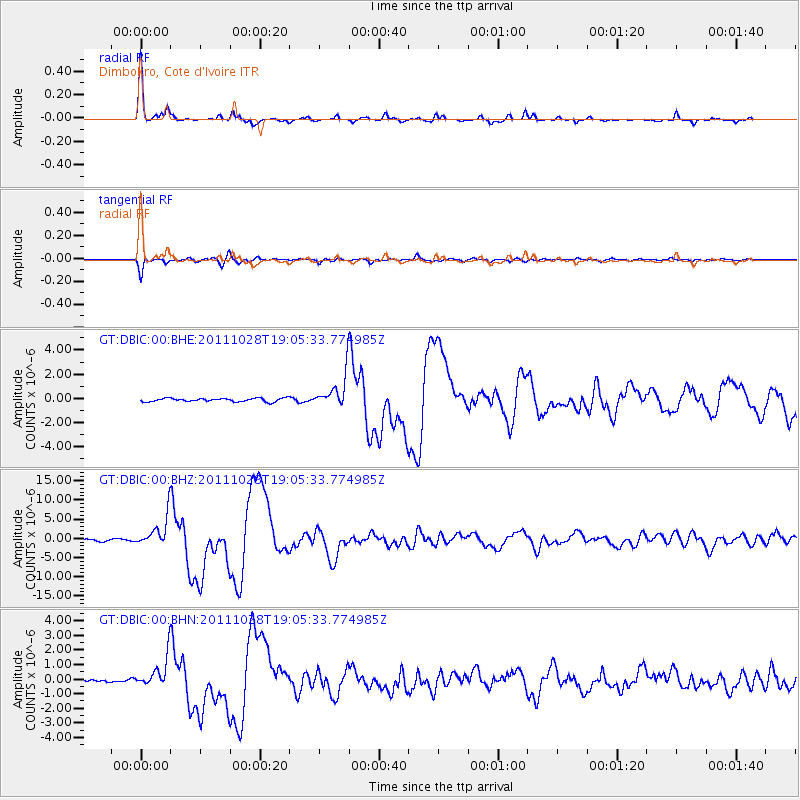
Signal To Noise
| Channel | StoN | STA | LTA |
| GT:DBIC:00:BHZ:20111028T19:05:33.774985Z | 17.985397 | 3.97513E-6 | 2.2101985E-7 |
| GT:DBIC:00:BHN:20111028T19:05:33.774985Z | 10.733788 | 1.0531323E-6 | 9.8113766E-8 |
| GT:DBIC:00:BHE:20111028T19:05:33.774985Z | 9.802593 | 1.3771872E-6 | 1.4049213E-7 |
| Arrivals |
| Ps | 4.4 SECOND |
| PpPs | 15 SECOND |
| PsPs/PpSs | 20 SECOND |


