You are here: Home > Network List > LD - Lamont-Doherty Cooperative Seismographic Network Stations List
> Station BRNY Black Rock Forest, Cornwall, NY > Earthquake Result Viewer
BRNY Black Rock Forest, Cornwall, NY - Earthquake Result Viewer
| Earthquake location: |
Near Coast Of Peru |
| Earthquake latitude/longitude: |
-14.4/-76.0 |
| Earthquake time(UTC): |
2011/10/28 (301) 18:54:34 GMT |
| Earthquake Depth: |
24 km |
| Earthquake Magnitude: |
6.5 MB, 6.9 MS, 6.9 MW, 6.9 MW |
| Earthquake Catalog/Contributor: |
WHDF/NEIC |
|
| Network: |
LD Lamont-Doherty Cooperative Seismographic Network |
| Station: |
BRNY Black Rock Forest, Cornwall, NY |
| Lat/Lon: |
41.41 N/74.01 W |
| Elevation: |
248 m |
|
| Distance: |
55.6 deg |
| Az: |
1.781 deg |
| Baz: |
182.295 deg |
| Ray Param: |
0.06465424 |
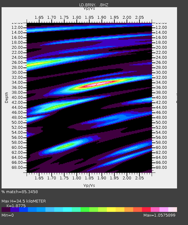
| Estimated Moho Depth: |
34.5 km |
| Estimated Crust Vp/Vs: |
1.88 |
| Assumed Crust Vp: |
6.283 km/s |
| Estimated Crust Vs: |
3.347 km/s |
| Estimated Crust Poisson's Ratio: |
0.30 |
|
| Radial Match: |
85.3458 % |
| Radial Bump: |
383 |
| Transverse Match: |
68.63766 % |
| Transverse Bump: |
400 |
| SOD ConfigId: |
424168 |
| Insert Time: |
2012-02-16 10:39:27.657 +0000 |
| GWidth: |
2.5 |
| Max Bumps: |
400 |
| Tol: |
0.001 |
|

Signal To Noise
| Channel | StoN | STA | LTA |
| LD:BRNY: :BHZ:20111028T19:03:36.725974Z | 6.689768 | 4.1508E-6 | 6.2047E-7 |
| LD:BRNY: :BHN:20111028T19:03:36.725974Z | 3.3979197 | 2.0942323E-6 | 6.163278E-7 |
| LD:BRNY: :BHE:20111028T19:03:36.725974Z | 1.0872148 | 4.828143E-7 | 4.4408364E-7 |
| Arrivals |
| Ps | 5.0 SECOND |
| PpPs | 15 SECOND |
| PsPs/PpSs | 20 SECOND |


