You are here: Home > Network List > LD - Lamont-Doherty Cooperative Seismographic Network Stations List
> Station PANJ Princeton, NJ > Earthquake Result Viewer
PANJ Princeton, NJ - Earthquake Result Viewer

| Earthquake location: |
Near Coast Of Peru |
| Earthquake latitude/longitude: |
-14.4/-76.0 |
| Earthquake time(UTC): |
2011/10/28 (301) 18:54:34 GMT |
| Earthquake Depth: |
24 km |
| Earthquake Magnitude: |
6.5 MB, 6.9 MS, 6.9 MW, 6.9 MW |
| Earthquake Catalog/Contributor: |
WHDF/NEIC |
|
| Network: |
LD Lamont-Doherty Cooperative Seismographic Network |
| Station: |
PANJ Princeton, NJ |
| Lat/Lon: |
40.38 N/74.70 W |
| Elevation: |
100 m |
|
| Distance: |
54.5 deg |
| Az: |
1.185 deg |
| Baz: |
181.502 deg |
| Ray Param: |
0.06534738 |
| Estimated Moho Depth: |
23.0 km |
| Estimated Crust Vp/Vs: |
1.68 |
| Assumed Crust Vp: |
6.283 km/s |
| Estimated Crust Vs: |
3.751 km/s |
| Estimated Crust Poisson's Ratio: |
0.22 |
|
| Radial Match: |
92.72728 % |
| Radial Bump: |
267 |
| Transverse Match: |
69.86075 % |
| Transverse Bump: |
400 |
| SOD ConfigId: |
424168 |
| Insert Time: |
2012-02-16 10:39:51.105 +0000 |
| GWidth: |
2.5 |
| Max Bumps: |
400 |
| Tol: |
0.001 |
|
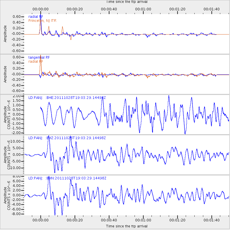
Signal To Noise
| Channel | StoN | STA | LTA |
| LD:PANJ: :BHZ:20111028T19:03:29.14498Z | 8.643028 | 4.700413E-6 | 5.438386E-7 |
| LD:PANJ: :BHN:20111028T19:03:29.14498Z | 8.011552 | 2.470159E-6 | 3.0832464E-7 |
| LD:PANJ: :BHE:20111028T19:03:29.14498Z | 0.80331147 | 5.7187395E-7 | 7.118957E-7 |
| Arrivals |
| Ps | 2.6 SECOND |
| PpPs | 9.3 SECOND |
| PsPs/PpSs | 12 SECOND |


