You are here: Home > Network List > NE - New England Seismic Network Stations List
> Station QUA2 Belchertown, MA > Earthquake Result Viewer
QUA2 Belchertown, MA - Earthquake Result Viewer
| Earthquake location: |
Near Coast Of Peru |
| Earthquake latitude/longitude: |
-14.4/-76.0 |
| Earthquake time(UTC): |
2011/10/28 (301) 18:54:34 GMT |
| Earthquake Depth: |
24 km |
| Earthquake Magnitude: |
6.5 MB, 6.9 MS, 6.9 MW, 6.9 MW |
| Earthquake Catalog/Contributor: |
WHDF/NEIC |
|
| Network: |
NE New England Seismic Network |
| Station: |
QUA2 Belchertown, MA |
| Lat/Lon: |
42.28 N/72.35 W |
| Elevation: |
175 m |
|
| Distance: |
56.5 deg |
| Az: |
3.215 deg |
| Baz: |
184.198 deg |
| Ray Param: |
0.06404689 |
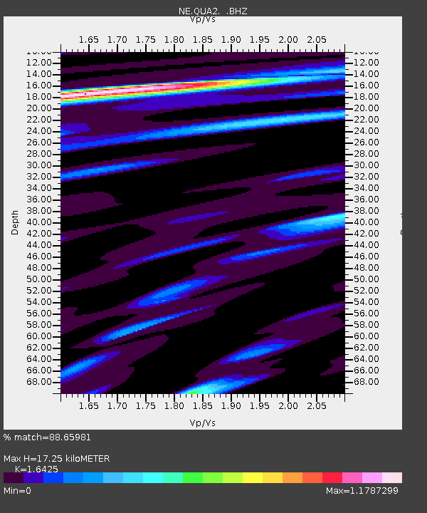
| Estimated Moho Depth: |
17.25 km |
| Estimated Crust Vp/Vs: |
1.64 |
| Assumed Crust Vp: |
6.419 km/s |
| Estimated Crust Vs: |
3.908 km/s |
| Estimated Crust Poisson's Ratio: |
0.21 |
|
| Radial Match: |
88.65981 % |
| Radial Bump: |
364 |
| Transverse Match: |
69.83352 % |
| Transverse Bump: |
400 |
| SOD ConfigId: |
424168 |
| Insert Time: |
2012-02-16 10:40:53.748 +0000 |
| GWidth: |
2.5 |
| Max Bumps: |
400 |
| Tol: |
0.001 |
|

Signal To Noise
| Channel | StoN | STA | LTA |
| NE:QUA2: :BHZ:20111028T19:03:43.389976Z | 2.7551694 | 3.4389427E-6 | 1.2481784E-6 |
| NE:QUA2: :BHN:20111028T19:03:43.389976Z | 3.6766174 | 2.1838973E-6 | 5.9399633E-7 |
| NE:QUA2: :BHE:20111028T19:03:43.389976Z | 0.5761307 | 4.782083E-7 | 8.300344E-7 |
| Arrivals |
| Ps | 1.8 SECOND |
| PpPs | 6.7 SECOND |
| PsPs/PpSs | 8.5 SECOND |


