You are here: Home > Network List > NE - New England Seismic Network Stations List
> Station EMMW Machias, ME > Earthquake Result Viewer
EMMW Machias, ME - Earthquake Result Viewer
| Earthquake location: |
Near Coast Of Peru |
| Earthquake latitude/longitude: |
-14.4/-76.0 |
| Earthquake time(UTC): |
2011/10/28 (301) 18:54:34 GMT |
| Earthquake Depth: |
24 km |
| Earthquake Magnitude: |
6.5 MB, 6.9 MS, 6.9 MW, 6.9 MW |
| Earthquake Catalog/Contributor: |
WHDF/NEIC |
|
| Network: |
NE New England Seismic Network |
| Station: |
EMMW Machias, ME |
| Lat/Lon: |
44.71 N/67.46 W |
| Elevation: |
34 m |
|
| Distance: |
59.4 deg |
| Az: |
7.042 deg |
| Baz: |
189.589 deg |
| Ray Param: |
0.062199313 |
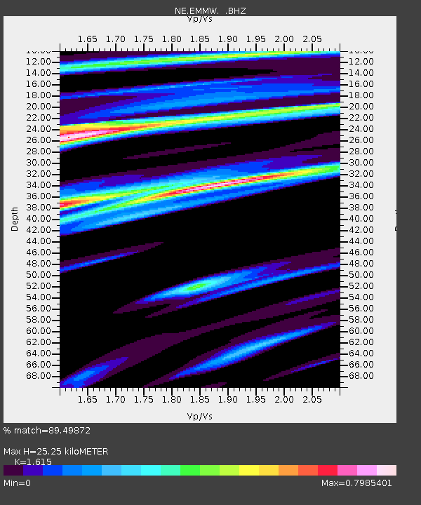
| Estimated Moho Depth: |
25.25 km |
| Estimated Crust Vp/Vs: |
1.62 |
| Assumed Crust Vp: |
6.419 km/s |
| Estimated Crust Vs: |
3.975 km/s |
| Estimated Crust Poisson's Ratio: |
0.19 |
|
| Radial Match: |
89.49872 % |
| Radial Bump: |
334 |
| Transverse Match: |
62.923775 % |
| Transverse Bump: |
400 |
| SOD ConfigId: |
424168 |
| Insert Time: |
2012-02-16 10:41:14.670 +0000 |
| GWidth: |
2.5 |
| Max Bumps: |
400 |
| Tol: |
0.001 |
|

Signal To Noise
| Channel | StoN | STA | LTA |
| NE:EMMW: :BHZ:20111028T19:04:03.26998Z | 2.786154 | 3.514921E-6 | 1.2615674E-6 |
| NE:EMMW: :BHN:20111028T19:04:03.26998Z | 2.6552923 | 1.5324649E-6 | 5.7713606E-7 |
| NE:EMMW: :BHE:20111028T19:04:03.26998Z | 1.164443 | 8.142777E-7 | 6.992851E-7 |
| Arrivals |
| Ps | 2.5 SECOND |
| PpPs | 9.8 SECOND |
| PsPs/PpSs | 12 SECOND |


