You are here: Home > Network List > NE - New England Seismic Network Stations List
> Station BRYW Smithfield, RI > Earthquake Result Viewer
BRYW Smithfield, RI - Earthquake Result Viewer
| Earthquake location: |
Near Coast Of Peru |
| Earthquake latitude/longitude: |
-14.4/-76.0 |
| Earthquake time(UTC): |
2011/10/28 (301) 18:54:34 GMT |
| Earthquake Depth: |
24 km |
| Earthquake Magnitude: |
6.5 MB, 6.9 MS, 6.9 MW, 6.9 MW |
| Earthquake Catalog/Contributor: |
WHDF/NEIC |
|
| Network: |
NE New England Seismic Network |
| Station: |
BRYW Smithfield, RI |
| Lat/Lon: |
41.92 N/71.54 W |
| Elevation: |
107 m |
|
| Distance: |
56.2 deg |
| Az: |
3.975 deg |
| Baz: |
185.163 deg |
| Ray Param: |
0.06424945 |
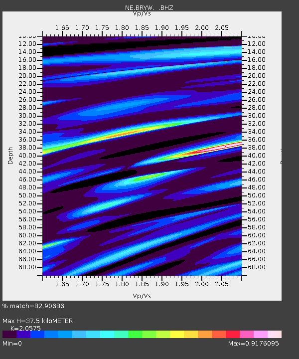
| Estimated Moho Depth: |
37.5 km |
| Estimated Crust Vp/Vs: |
2.06 |
| Assumed Crust Vp: |
6.472 km/s |
| Estimated Crust Vs: |
3.146 km/s |
| Estimated Crust Poisson's Ratio: |
0.35 |
|
| Radial Match: |
82.90686 % |
| Radial Bump: |
400 |
| Transverse Match: |
65.17493 % |
| Transverse Bump: |
400 |
| SOD ConfigId: |
424168 |
| Insert Time: |
2012-02-16 10:41:19.099 +0000 |
| GWidth: |
2.5 |
| Max Bumps: |
400 |
| Tol: |
0.001 |
|

Signal To Noise
| Channel | StoN | STA | LTA |
| NE:BRYW: :BHZ:20111028T19:03:41.170005Z | 5.7859635 | 4.433963E-6 | 7.6633097E-7 |
| NE:BRYW: :BHN:20111028T19:03:41.170005Z | 4.163334 | 3.4591503E-6 | 8.3086064E-7 |
| NE:BRYW: :BHE:20111028T19:03:41.170005Z | 2.156109 | 1.2891844E-6 | 5.9792177E-7 |
| Arrivals |
| Ps | 6.4 SECOND |
| PpPs | 17 SECOND |
| PsPs/PpSs | 23 SECOND |


