You are here: Home > Network List > NM - Cooperative New Madrid Seismic Network Stations List
> Station USIN Univ. of Southern Indiana, Evansville, IN > Earthquake Result Viewer
USIN Univ. of Southern Indiana, Evansville, IN - Earthquake Result Viewer
| Earthquake location: |
Near Coast Of Peru |
| Earthquake latitude/longitude: |
-14.4/-76.0 |
| Earthquake time(UTC): |
2011/10/28 (301) 18:54:34 GMT |
| Earthquake Depth: |
24 km |
| Earthquake Magnitude: |
6.5 MB, 6.9 MS, 6.9 MW, 6.9 MW |
| Earthquake Catalog/Contributor: |
WHDF/NEIC |
|
| Network: |
NM Cooperative New Madrid Seismic Network |
| Station: |
USIN Univ. of Southern Indiana, Evansville, IN |
| Lat/Lon: |
37.97 N/87.67 W |
| Elevation: |
1707 m |
|
| Distance: |
53.3 deg |
| Az: |
348.464 deg |
| Baz: |
165.81 deg |
| Ray Param: |
0.066175975 |
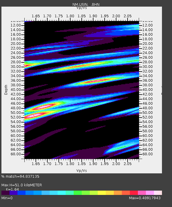
| Estimated Moho Depth: |
51.0 km |
| Estimated Crust Vp/Vs: |
1.64 |
| Assumed Crust Vp: |
6.444 km/s |
| Estimated Crust Vs: |
3.929 km/s |
| Estimated Crust Poisson's Ratio: |
0.20 |
|
| Radial Match: |
94.837135 % |
| Radial Bump: |
271 |
| Transverse Match: |
71.71853 % |
| Transverse Bump: |
400 |
| SOD ConfigId: |
424168 |
| Insert Time: |
2012-02-16 10:41:30.674 +0000 |
| GWidth: |
2.5 |
| Max Bumps: |
400 |
| Tol: |
0.001 |
|

Signal To Noise
| Channel | StoN | STA | LTA |
| NM:USIN: :BHZ:20111028T19:03:19.844993Z | 11.934898 | 4.3571367E-6 | 3.6507532E-7 |
| NM:USIN: :BHN:20111028T19:03:19.844993Z | 5.441251 | 2.2816978E-6 | 4.193333E-7 |
| NM:USIN: :BHE:20111028T19:03:19.844993Z | 1.2992826 | 6.0217116E-7 | 4.6346435E-7 |
| Arrivals |
| Ps | 5.4 SECOND |
| PpPs | 20 SECOND |
| PsPs/PpSs | 25 SECOND |


