You are here: Home > Network List > G - GEOSCOPE Stations List
> Station HYB Hyderabad, India > Earthquake Result Viewer
HYB Hyderabad, India - Earthquake Result Viewer
| Earthquake location: |
Samar, Philippines |
| Earthquake latitude/longitude: |
12.2/124.1 |
| Earthquake time(UTC): |
2003/02/15 (046) 11:01:59 GMT |
| Earthquake Depth: |
10 km |
| Earthquake Magnitude: |
5.8 MB, 6.2 MS, 6.3 MW, 6.2 MW |
| Earthquake Catalog/Contributor: |
WHDF/NEIC |
|
| Network: |
G GEOSCOPE |
| Station: |
HYB Hyderabad, India |
| Lat/Lon: |
17.42 N/78.55 E |
| Elevation: |
510 m |
|
| Distance: |
44.2 deg |
| Az: |
282.483 deg |
| Baz: |
90.316 deg |
| Ray Param: |
0.07203402 |
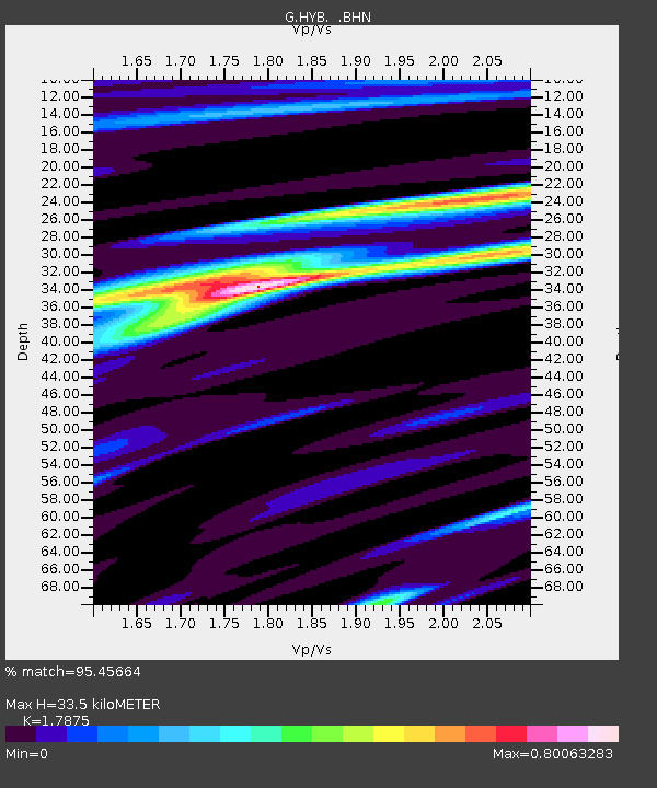
| Estimated Moho Depth: |
33.5 km |
| Estimated Crust Vp/Vs: |
1.79 |
| Assumed Crust Vp: |
6.459 km/s |
| Estimated Crust Vs: |
3.614 km/s |
| Estimated Crust Poisson's Ratio: |
0.27 |
|
| Radial Match: |
95.45664 % |
| Radial Bump: |
238 |
| Transverse Match: |
65.38411 % |
| Transverse Bump: |
400 |
| SOD ConfigId: |
4714 |
| Insert Time: |
2010-02-26 22:43:30.133 +0000 |
| GWidth: |
2.5 |
| Max Bumps: |
400 |
| Tol: |
0.001 |
|
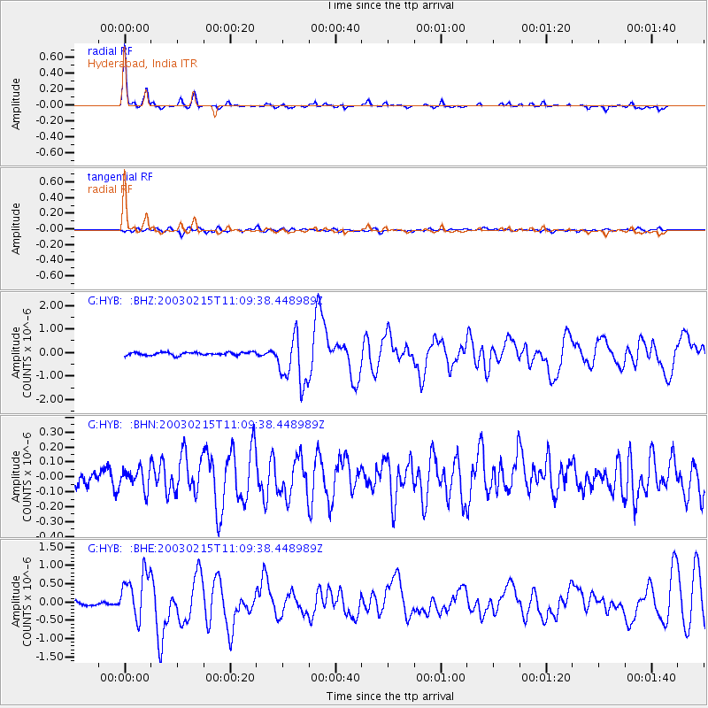
Signal To Noise
| Channel | StoN | STA | LTA |
| G:HYB: :BHN:20030215T11:09:38.448989Z | 1.3756784 | 7.1288724E-8 | 5.1820773E-8 |
| G:HYB: :BHE:20030215T11:09:38.448989Z | 14.001212 | 6.4757427E-7 | 4.62513E-8 |
| G:HYB: :BHZ:20030215T11:09:38.448989Z | 17.31378 | 1.0737083E-6 | 6.201467E-8 |
| Arrivals |
| Ps | 4.4 SECOND |
| PpPs | 14 SECOND |
| PsPs/PpSs | 18 SECOND |


