You are here: Home > Network List > TA - USArray Transportable Network (new EarthScope stations) Stations List
> Station MSTX Muleshoe, TX, USA > Earthquake Result Viewer
MSTX Muleshoe, TX, USA - Earthquake Result Viewer

| Earthquake location: |
Near Coast Of Peru |
| Earthquake latitude/longitude: |
-14.4/-76.0 |
| Earthquake time(UTC): |
2011/10/28 (301) 18:54:34 GMT |
| Earthquake Depth: |
24 km |
| Earthquake Magnitude: |
6.5 MB, 6.9 MS, 6.9 MW, 6.9 MW |
| Earthquake Catalog/Contributor: |
WHDF/NEIC |
|
| Network: |
TA USArray Transportable Network (new EarthScope stations) |
| Station: |
MSTX Muleshoe, TX, USA |
| Lat/Lon: |
33.97 N/102.77 W |
| Elevation: |
1167 m |
|
| Distance: |
54.5 deg |
| Az: |
332.586 deg |
| Baz: |
147.538 deg |
| Ray Param: |
0.065381005 |
| Estimated Moho Depth: |
36.25 km |
| Estimated Crust Vp/Vs: |
1.98 |
| Assumed Crust Vp: |
6.129 km/s |
| Estimated Crust Vs: |
3.103 km/s |
| Estimated Crust Poisson's Ratio: |
0.33 |
|
| Radial Match: |
95.71176 % |
| Radial Bump: |
208 |
| Transverse Match: |
79.594955 % |
| Transverse Bump: |
381 |
| SOD ConfigId: |
424168 |
| Insert Time: |
2012-02-16 10:43:38.361 +0000 |
| GWidth: |
2.5 |
| Max Bumps: |
400 |
| Tol: |
0.001 |
|
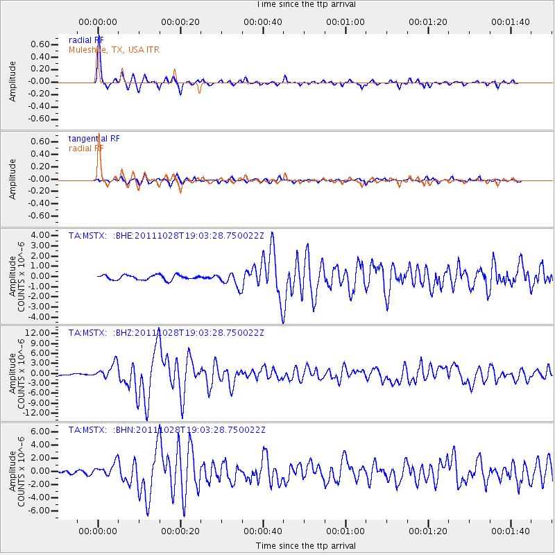
Signal To Noise
| Channel | StoN | STA | LTA |
| TA:MSTX: :BHZ:20111028T19:03:28.750022Z | 9.87298 | 2.3604132E-6 | 2.3907808E-7 |
| TA:MSTX: :BHN:20111028T19:03:28.750022Z | 3.595379 | 1.023797E-6 | 2.8475355E-7 |
| TA:MSTX: :BHE:20111028T19:03:28.750022Z | 3.1488738 | 7.359589E-7 | 2.3372132E-7 |
| Arrivals |
| Ps | 6.0 SECOND |
| PpPs | 17 SECOND |
| PsPs/PpSs | 23 SECOND |


