You are here: Home > Network List > CI - Caltech Regional Seismic Network Stations List
> Station LGU LGU, Camarillo, CA, USA > Earthquake Result Viewer
LGU LGU, Camarillo, CA, USA - Earthquake Result Viewer
| Earthquake location: |
Mariana Islands |
| Earthquake latitude/longitude: |
20.1/145.8 |
| Earthquake time(UTC): |
2005/08/13 (225) 07:36:52 GMT |
| Earthquake Depth: |
49 km |
| Earthquake Magnitude: |
5.8 MB, 5.6 MS, 6.0 MW, 6.0 MW |
| Earthquake Catalog/Contributor: |
WHDF/NEIC |
|
| Network: |
CI Caltech Regional Seismic Network |
| Station: |
LGU LGU, Camarillo, CA, USA |
| Lat/Lon: |
34.11 N/119.07 W |
| Elevation: |
416 m |
|
| Distance: |
83.0 deg |
| Az: |
56.36 deg |
| Baz: |
289.469 deg |
| Ray Param: |
0.04638953 |
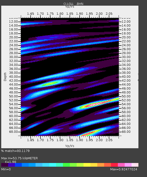
| Estimated Moho Depth: |
53.75 km |
| Estimated Crust Vp/Vs: |
1.98 |
| Assumed Crust Vp: |
6.1 km/s |
| Estimated Crust Vs: |
3.081 km/s |
| Estimated Crust Poisson's Ratio: |
0.33 |
|
| Radial Match: |
80.1179 % |
| Radial Bump: |
400 |
| Transverse Match: |
75.51859 % |
| Transverse Bump: |
400 |
| SOD ConfigId: |
2422 |
| Insert Time: |
2010-02-25 20:19:43.692 +0000 |
| GWidth: |
2.5 |
| Max Bumps: |
400 |
| Tol: |
0.001 |
|
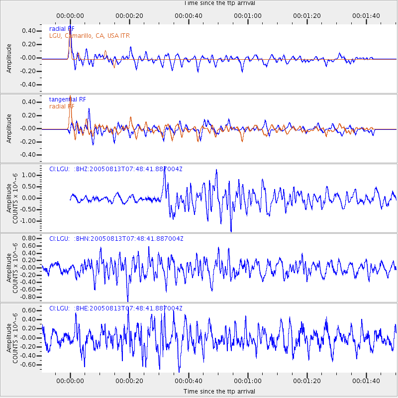
Signal To Noise
| Channel | StoN | STA | LTA |
| CI:LGU: :BHN:20050813T07:48:41.887004Z | 1.1668812 | 1.2502665E-7 | 1.0714599E-7 |
| CI:LGU: :BHE:20050813T07:48:41.887004Z | 1.5140723 | 2.4972576E-7 | 1.6493648E-7 |
| CI:LGU: :BHZ:20050813T07:48:41.887004Z | 5.0288477 | 5.518198E-7 | 1.0973087E-7 |
| Arrivals |
| Ps | 8.8 SECOND |
| PpPs | 26 SECOND |
| PsPs/PpSs | 35 SECOND |


