You are here: Home > Network List > TA - USArray Transportable Network (new EarthScope stations) Stations List
> Station 437A Phaontom Ranch, North Zulch, TX, USA > Earthquake Result Viewer
437A Phaontom Ranch, North Zulch, TX, USA - Earthquake Result Viewer
| Earthquake location: |
Near Coast Of Peru |
| Earthquake latitude/longitude: |
-14.4/-76.0 |
| Earthquake time(UTC): |
2011/10/28 (301) 18:54:34 GMT |
| Earthquake Depth: |
24 km |
| Earthquake Magnitude: |
6.5 MB, 6.9 MS, 6.9 MW, 6.9 MW |
| Earthquake Catalog/Contributor: |
WHDF/NEIC |
|
| Network: |
TA USArray Transportable Network (new EarthScope stations) |
| Station: |
437A Phaontom Ranch, North Zulch, TX, USA |
| Lat/Lon: |
30.83 N/96.14 W |
| Elevation: |
95 m |
|
| Distance: |
49.0 deg |
| Az: |
336.859 deg |
| Baz: |
153.729 deg |
| Ray Param: |
0.068940654 |
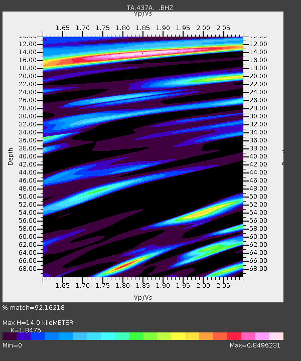
| Estimated Moho Depth: |
14.0 km |
| Estimated Crust Vp/Vs: |
1.85 |
| Assumed Crust Vp: |
6.347 km/s |
| Estimated Crust Vs: |
3.435 km/s |
| Estimated Crust Poisson's Ratio: |
0.29 |
|
| Radial Match: |
92.16218 % |
| Radial Bump: |
400 |
| Transverse Match: |
76.21574 % |
| Transverse Bump: |
400 |
| SOD ConfigId: |
424168 |
| Insert Time: |
2012-02-16 10:46:55.673 +0000 |
| GWidth: |
2.5 |
| Max Bumps: |
400 |
| Tol: |
0.001 |
|
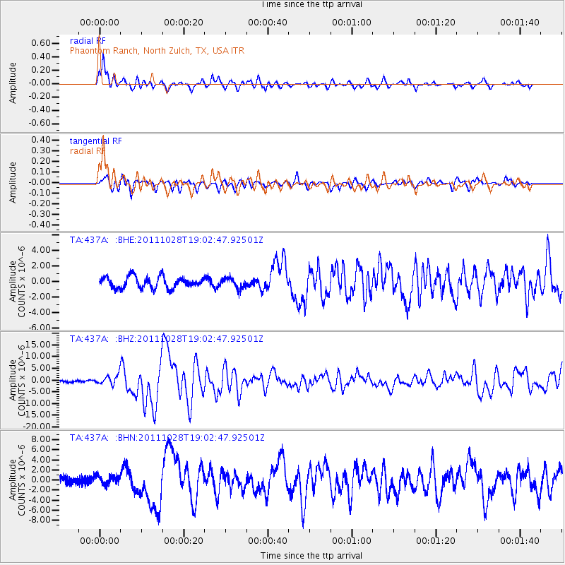
Signal To Noise
| Channel | StoN | STA | LTA |
| TA:437A: :BHZ:20111028T19:02:47.92501Z | 4.9028683 | 2.0743744E-6 | 4.2309406E-7 |
| TA:437A: :BHN:20111028T19:02:47.92501Z | 1.0892054 | 8.8051274E-7 | 8.083992E-7 |
| TA:437A: :BHE:20111028T19:02:47.92501Z | 0.92107844 | 6.685464E-7 | 7.2583003E-7 |
| Arrivals |
| Ps | 2.0 SECOND |
| PpPs | 5.9 SECOND |
| PsPs/PpSs | 7.9 SECOND |


