You are here: Home > Network List > G - GEOSCOPE Stations List
> Station HYB Hyderabad, India > Earthquake Result Viewer
HYB Hyderabad, India - Earthquake Result Viewer

| Earthquake location: |
Seram, Indonesia |
| Earthquake latitude/longitude: |
-3.2/127.5 |
| Earthquake time(UTC): |
2003/03/30 (089) 18:13:34 GMT |
| Earthquake Depth: |
33 km |
| Earthquake Magnitude: |
5.8 MB, 6.0 MS, 6.2 MW, 6.2 MW |
| Earthquake Catalog/Contributor: |
WHDF/NEIC |
|
| Network: |
G GEOSCOPE |
| Station: |
HYB Hyderabad, India |
| Lat/Lon: |
17.42 N/78.55 E |
| Elevation: |
510 m |
|
| Distance: |
52.5 deg |
| Az: |
294.706 deg |
| Baz: |
108.175 deg |
| Ray Param: |
0.066680014 |
| Estimated Moho Depth: |
33.0 km |
| Estimated Crust Vp/Vs: |
1.75 |
| Assumed Crust Vp: |
6.459 km/s |
| Estimated Crust Vs: |
3.702 km/s |
| Estimated Crust Poisson's Ratio: |
0.26 |
|
| Radial Match: |
96.13639 % |
| Radial Bump: |
192 |
| Transverse Match: |
85.93342 % |
| Transverse Bump: |
400 |
| SOD ConfigId: |
4714 |
| Insert Time: |
2010-02-26 22:43:45.272 +0000 |
| GWidth: |
2.5 |
| Max Bumps: |
400 |
| Tol: |
0.001 |
|
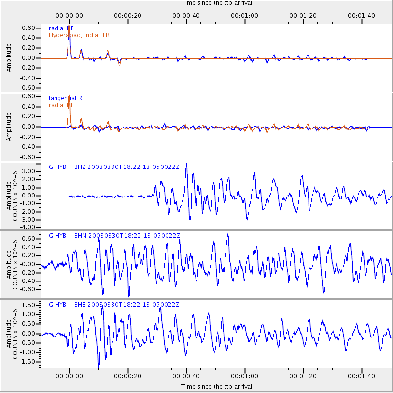
Signal To Noise
| Channel | StoN | STA | LTA |
| G:HYB: :BHN:20030330T18:22:13.050022Z | 6.291546 | 2.1759622E-7 | 3.4585494E-8 |
| G:HYB: :BHE:20030330T18:22:13.050022Z | 14.041061 | 5.926119E-7 | 4.2205635E-8 |
| G:HYB: :BHZ:20030330T18:22:13.050022Z | 19.091604 | 1.1929232E-6 | 6.2484176E-8 |
| Arrivals |
| Ps | 4.0 SECOND |
| PpPs | 13 SECOND |
| PsPs/PpSs | 17 SECOND |


