You are here: Home > Network List > TA - USArray Transportable Network (new EarthScope stations) Stations List
> Station Z38A Mt. Pleasant, TX, USA > Earthquake Result Viewer
Z38A Mt. Pleasant, TX, USA - Earthquake Result Viewer
| Earthquake location: |
Near Coast Of Peru |
| Earthquake latitude/longitude: |
-14.4/-76.0 |
| Earthquake time(UTC): |
2011/10/28 (301) 18:54:34 GMT |
| Earthquake Depth: |
24 km |
| Earthquake Magnitude: |
6.5 MB, 6.9 MS, 6.9 MW, 6.9 MW |
| Earthquake Catalog/Contributor: |
WHDF/NEIC |
|
| Network: |
TA USArray Transportable Network (new EarthScope stations) |
| Station: |
Z38A Mt. Pleasant, TX, USA |
| Lat/Lon: |
33.25 N/94.99 W |
| Elevation: |
116 m |
|
| Distance: |
50.8 deg |
| Az: |
339.36 deg |
| Baz: |
155.95 deg |
| Ray Param: |
0.06779035 |
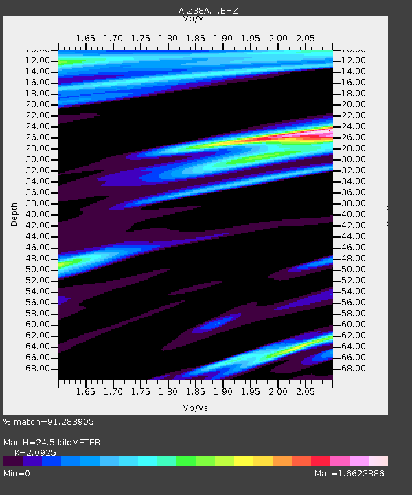
| Estimated Moho Depth: |
24.5 km |
| Estimated Crust Vp/Vs: |
2.09 |
| Assumed Crust Vp: |
6.245 km/s |
| Estimated Crust Vs: |
2.985 km/s |
| Estimated Crust Poisson's Ratio: |
0.35 |
|
| Radial Match: |
91.283905 % |
| Radial Bump: |
302 |
| Transverse Match: |
76.01561 % |
| Transverse Bump: |
400 |
| SOD ConfigId: |
424168 |
| Insert Time: |
2012-02-16 10:48:54.334 +0000 |
| GWidth: |
2.5 |
| Max Bumps: |
400 |
| Tol: |
0.001 |
|

Signal To Noise
| Channel | StoN | STA | LTA |
| TA:Z38A: :BHZ:20111028T19:03:01.42501Z | 5.3920517 | 2.6770033E-6 | 4.964721E-7 |
| TA:Z38A: :BHN:20111028T19:03:01.42501Z | 1.2814169 | 6.800275E-7 | 5.30684E-7 |
| TA:Z38A: :BHE:20111028T19:03:01.42501Z | 0.6791673 | 5.8015826E-7 | 8.5421993E-7 |
| Arrivals |
| Ps | 4.5 SECOND |
| PpPs | 12 SECOND |
| PsPs/PpSs | 16 SECOND |


