You are here: Home > Network List > TA - USArray Transportable Network (new EarthScope stations) Stations List
> Station 236A Katherine and Luke Keathley, Corsicana, TX, USA > Earthquake Result Viewer
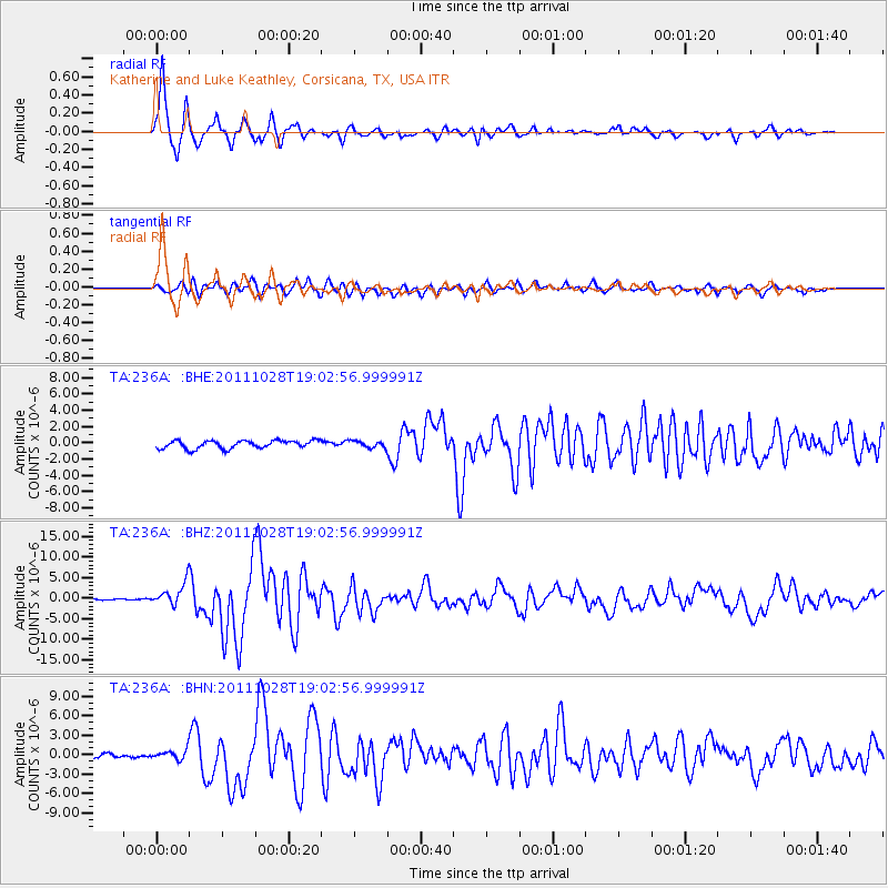
236A Katherine and Luke Keathley, Corsicana, TX, USA - Earthquake Result Viewer
| Earthquake location: |
Near Coast Of Peru |
| Earthquake latitude/longitude: |
-14.4/-76.0 |
| Earthquake time(UTC): |
2011/10/28 (301) 18:54:34 GMT |
| Earthquake Depth: |
24 km |
| Earthquake Magnitude: |
6.5 MB, 6.9 MS, 6.9 MW, 6.9 MW |
| Earthquake Catalog/Contributor: |
WHDF/NEIC |
|
| Network: |
TA USArray Transportable Network (new EarthScope stations) |
| Station: |
236A Katherine and Luke Keathley, Corsicana, TX, USA |
| Lat/Lon: |
32.00 N/96.53 W |
| Elevation: |
118 m |
|
| Distance: |
50.2 deg |
| Az: |
337.143 deg |
| Baz: |
153.71 deg |
| Ray Param: |
0.06817504 |
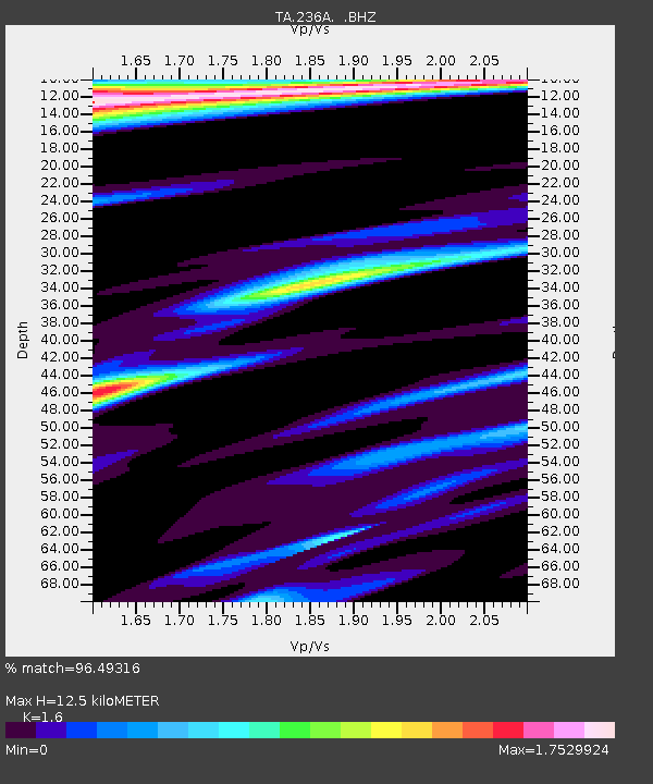
| Estimated Moho Depth: |
12.5 km |
| Estimated Crust Vp/Vs: |
1.60 |
| Assumed Crust Vp: |
6.347 km/s |
| Estimated Crust Vs: |
3.967 km/s |
| Estimated Crust Poisson's Ratio: |
0.18 |
|
| Radial Match: |
96.49316 % |
| Radial Bump: |
400 |
| Transverse Match: |
84.63712 % |
| Transverse Bump: |
400 |
| SOD ConfigId: |
424168 |
| Insert Time: |
2012-02-16 10:49:13.161 +0000 |
| GWidth: |
2.5 |
| Max Bumps: |
400 |
| Tol: |
0.001 |
|
Signal To Noise
| Channel | StoN | STA | LTA |
| TA:236A: :BHZ:20111028T19:02:56.999991Z | 14.466193 | 2.6643622E-6 | 1.8417853E-7 |
| TA:236A: :BHN:20111028T19:02:56.999991Z | 2.445036 | 7.045369E-7 | 2.881499E-7 |
| TA:236A: :BHE:20111028T19:02:56.999991Z | 0.84799063 | 4.1558818E-7 | 4.900858E-7 |
| Arrivals |
| Ps | 1.3 SECOND |
| PpPs | 4.8 SECOND |
| PsPs/PpSs | 6.1 SECOND |


