You are here: Home > Network List > TA - USArray Transportable Network (new EarthScope stations) Stations List
> Station Y36A Durant, OK, USA > Earthquake Result Viewer
Y36A Durant, OK, USA - Earthquake Result Viewer
| Earthquake location: |
Near Coast Of Peru |
| Earthquake latitude/longitude: |
-14.4/-76.0 |
| Earthquake time(UTC): |
2011/10/28 (301) 18:54:34 GMT |
| Earthquake Depth: |
24 km |
| Earthquake Magnitude: |
6.5 MB, 6.9 MS, 6.9 MW, 6.9 MW |
| Earthquake Catalog/Contributor: |
WHDF/NEIC |
|
| Network: |
TA USArray Transportable Network (new EarthScope stations) |
| Station: |
Y36A Durant, OK, USA |
| Lat/Lon: |
33.90 N/96.28 W |
| Elevation: |
186 m |
|
| Distance: |
51.8 deg |
| Az: |
338.444 deg |
| Baz: |
154.662 deg |
| Ray Param: |
0.06712479 |
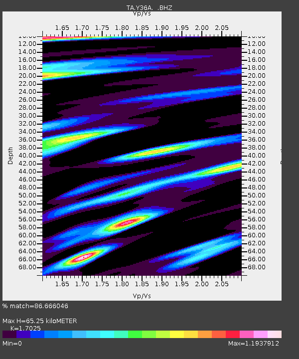
| Estimated Moho Depth: |
65.25 km |
| Estimated Crust Vp/Vs: |
1.70 |
| Assumed Crust Vp: |
6.38 km/s |
| Estimated Crust Vs: |
3.748 km/s |
| Estimated Crust Poisson's Ratio: |
0.24 |
|
| Radial Match: |
86.666046 % |
| Radial Bump: |
400 |
| Transverse Match: |
74.6578 % |
| Transverse Bump: |
400 |
| SOD ConfigId: |
424168 |
| Insert Time: |
2012-02-16 10:49:14.518 +0000 |
| GWidth: |
2.5 |
| Max Bumps: |
400 |
| Tol: |
0.001 |
|

Signal To Noise
| Channel | StoN | STA | LTA |
| TA:Y36A: :BHZ:20111028T19:03:09.125022Z | 6.9668818 | 2.864829E-6 | 4.1120674E-7 |
| TA:Y36A: :BHN:20111028T19:03:09.125022Z | 1.872993 | 8.8362617E-7 | 4.7177227E-7 |
| TA:Y36A: :BHE:20111028T19:03:09.125022Z | 2.4480019 | 7.830805E-7 | 3.198856E-7 |
| Arrivals |
| Ps | 7.6 SECOND |
| PpPs | 26 SECOND |
| PsPs/PpSs | 34 SECOND |


