You are here: Home > Network List > TA - USArray Transportable Network (new EarthScope stations) Stations List
> Station Z39A Irene McRaven, Queen City, TX, USA > Earthquake Result Viewer
Z39A Irene McRaven, Queen City, TX, USA - Earthquake Result Viewer
| Earthquake location: |
Near Coast Of Peru |
| Earthquake latitude/longitude: |
-14.4/-76.0 |
| Earthquake time(UTC): |
2011/10/28 (301) 18:54:34 GMT |
| Earthquake Depth: |
24 km |
| Earthquake Magnitude: |
6.5 MB, 6.9 MS, 6.9 MW, 6.9 MW |
| Earthquake Catalog/Contributor: |
WHDF/NEIC |
|
| Network: |
TA USArray Transportable Network (new EarthScope stations) |
| Station: |
Z39A Irene McRaven, Queen City, TX, USA |
| Lat/Lon: |
33.24 N/94.18 W |
| Elevation: |
112 m |
|
| Distance: |
50.5 deg |
| Az: |
340.154 deg |
| Baz: |
156.891 deg |
| Ray Param: |
0.06797576 |
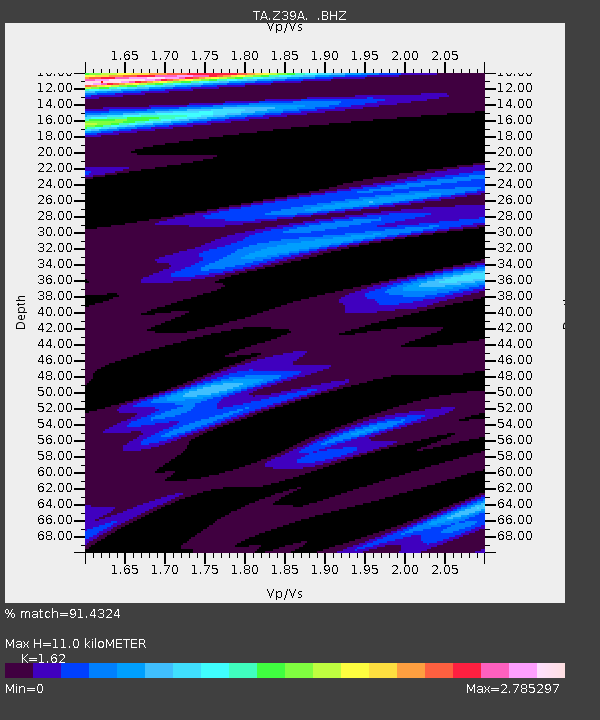
| Estimated Moho Depth: |
11.0 km |
| Estimated Crust Vp/Vs: |
1.62 |
| Assumed Crust Vp: |
6.245 km/s |
| Estimated Crust Vs: |
3.855 km/s |
| Estimated Crust Poisson's Ratio: |
0.19 |
|
| Radial Match: |
91.4324 % |
| Radial Bump: |
295 |
| Transverse Match: |
76.80763 % |
| Transverse Bump: |
400 |
| SOD ConfigId: |
424168 |
| Insert Time: |
2012-02-16 10:49:27.344 +0000 |
| GWidth: |
2.5 |
| Max Bumps: |
400 |
| Tol: |
0.001 |
|
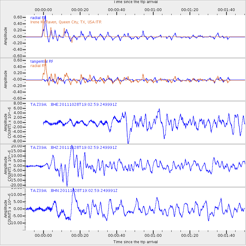
Signal To Noise
| Channel | StoN | STA | LTA |
| TA:Z39A: :BHZ:20111028T19:02:59.249991Z | 7.3058634 | 2.3768E-6 | 3.2532773E-7 |
| TA:Z39A: :BHN:20111028T19:02:59.249991Z | 1.2386599 | 8.378853E-7 | 6.7644504E-7 |
| TA:Z39A: :BHE:20111028T19:02:59.249991Z | 1.169058 | 7.472529E-7 | 6.391923E-7 |
| Arrivals |
| Ps | 1.2 SECOND |
| PpPs | 4.3 SECOND |
| PsPs/PpSs | 5.5 SECOND |


