You are here: Home > Network List > TA - USArray Transportable Network (new EarthScope stations) Stations List
> Station Y39A Lockesburg, AR, USA > Earthquake Result Viewer
Y39A Lockesburg, AR, USA - Earthquake Result Viewer
| Earthquake location: |
Near Coast Of Peru |
| Earthquake latitude/longitude: |
-14.4/-76.0 |
| Earthquake time(UTC): |
2011/10/28 (301) 18:54:34 GMT |
| Earthquake Depth: |
24 km |
| Earthquake Magnitude: |
6.5 MB, 6.9 MS, 6.9 MW, 6.9 MW |
| Earthquake Catalog/Contributor: |
WHDF/NEIC |
|
| Network: |
TA USArray Transportable Network (new EarthScope stations) |
| Station: |
Y39A Lockesburg, AR, USA |
| Lat/Lon: |
33.94 N/94.09 W |
| Elevation: |
108 m |
|
| Distance: |
51.1 deg |
| Az: |
340.591 deg |
| Baz: |
157.216 deg |
| Ray Param: |
0.067582205 |
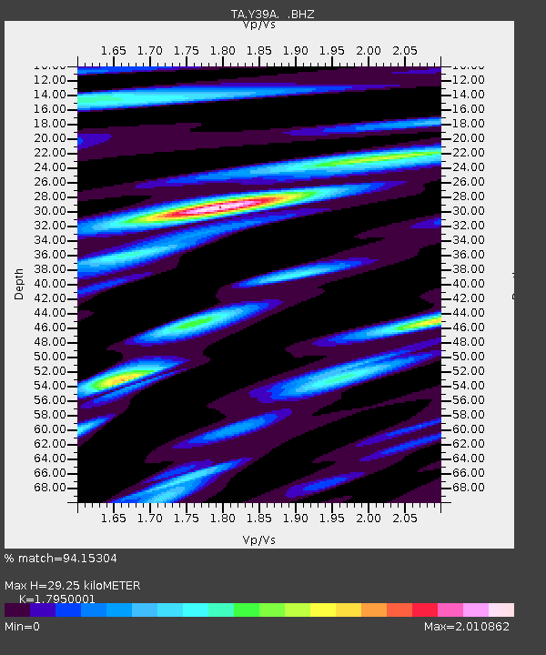
| Estimated Moho Depth: |
29.25 km |
| Estimated Crust Vp/Vs: |
1.80 |
| Assumed Crust Vp: |
6.245 km/s |
| Estimated Crust Vs: |
3.479 km/s |
| Estimated Crust Poisson's Ratio: |
0.27 |
|
| Radial Match: |
94.15304 % |
| Radial Bump: |
400 |
| Transverse Match: |
71.99054 % |
| Transverse Bump: |
400 |
| SOD ConfigId: |
424168 |
| Insert Time: |
2012-02-16 10:49:55.078 +0000 |
| GWidth: |
2.5 |
| Max Bumps: |
400 |
| Tol: |
0.001 |
|

Signal To Noise
| Channel | StoN | STA | LTA |
| TA:Y39A: :BHZ:20111028T19:03:03.849998Z | 10.423303 | 2.9419587E-6 | 2.822482E-7 |
| TA:Y39A: :BHN:20111028T19:03:03.849998Z | 3.6580403 | 1.4008258E-6 | 3.8294434E-7 |
| TA:Y39A: :BHE:20111028T19:03:03.849998Z | 1.7338823 | 5.4292934E-7 | 3.131293E-7 |
| Arrivals |
| Ps | 3.9 SECOND |
| PpPs | 12 SECOND |
| PsPs/PpSs | 16 SECOND |


