You are here: Home > Network List > TA - USArray Transportable Network (new EarthScope stations) Stations List
> Station T37A Cheneyville 1850, Columbus, KS, USA > Earthquake Result Viewer
T37A Cheneyville 1850, Columbus, KS, USA - Earthquake Result Viewer
| Earthquake location: |
Near Coast Of Peru |
| Earthquake latitude/longitude: |
-14.4/-76.0 |
| Earthquake time(UTC): |
2011/10/28 (301) 18:54:34 GMT |
| Earthquake Depth: |
24 km |
| Earthquake Magnitude: |
6.5 MB, 6.9 MS, 6.9 MW, 6.9 MW |
| Earthquake Catalog/Contributor: |
WHDF/NEIC |
|
| Network: |
TA USArray Transportable Network (new EarthScope stations) |
| Station: |
T37A Cheneyville 1850, Columbus, KS, USA |
| Lat/Lon: |
37.12 N/94.92 W |
| Elevation: |
256 m |
|
| Distance: |
54.3 deg |
| Az: |
341.359 deg |
| Baz: |
157.205 deg |
| Ray Param: |
0.0654982 |
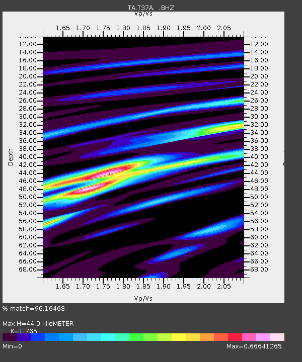
| Estimated Moho Depth: |
44.0 km |
| Estimated Crust Vp/Vs: |
1.76 |
| Assumed Crust Vp: |
6.53 km/s |
| Estimated Crust Vs: |
3.7 km/s |
| Estimated Crust Poisson's Ratio: |
0.26 |
|
| Radial Match: |
96.16468 % |
| Radial Bump: |
274 |
| Transverse Match: |
84.82685 % |
| Transverse Bump: |
400 |
| SOD ConfigId: |
424168 |
| Insert Time: |
2012-02-16 10:51:06.877 +0000 |
| GWidth: |
2.5 |
| Max Bumps: |
400 |
| Tol: |
0.001 |
|

Signal To Noise
| Channel | StoN | STA | LTA |
| TA:T37A: :BHZ:20111028T19:03:27.375022Z | 12.512941 | 3.9317383E-6 | 3.1421376E-7 |
| TA:T37A: :BHN:20111028T19:03:27.375022Z | 9.830077 | 1.9686545E-6 | 2.0026847E-7 |
| TA:T37A: :BHE:20111028T19:03:27.375022Z | 3.6525538 | 7.404477E-7 | 2.0272056E-7 |
| Arrivals |
| Ps | 5.4 SECOND |
| PpPs | 18 SECOND |
| PsPs/PpSs | 23 SECOND |


