You are here: Home > Network List > TA - USArray Transportable Network (new EarthScope stations) Stations List
> Station U36A Oologah, OK, USA > Earthquake Result Viewer
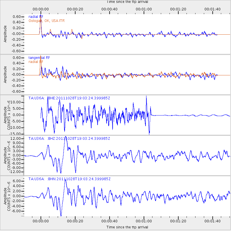
U36A Oologah, OK, USA - Earthquake Result Viewer
*The percent match for this event was below the threshold and hence no stack was calculated.
| Earthquake location: |
Near Coast Of Peru |
| Earthquake latitude/longitude: |
-14.4/-76.0 |
| Earthquake time(UTC): |
2011/10/28 (301) 18:54:34 GMT |
| Earthquake Depth: |
24 km |
| Earthquake Magnitude: |
6.5 MB, 6.9 MS, 6.9 MW, 6.9 MW |
| Earthquake Catalog/Contributor: |
WHDF/NEIC |
|
| Network: |
TA USArray Transportable Network (new EarthScope stations) |
| Station: |
U36A Oologah, OK, USA |
| Lat/Lon: |
36.39 N/95.73 W |
| Elevation: |
187 m |
|
| Distance: |
53.9 deg |
| Az: |
340.26 deg |
| Baz: |
156.075 deg |
| Ray Param: |
$rayparam |
*The percent match for this event was below the threshold and hence was not used in the summary stack. |
|
| Radial Match: |
66.03203 % |
| Radial Bump: |
328 |
| Transverse Match: |
24.452936 % |
| Transverse Bump: |
351 |
| SOD ConfigId: |
424168 |
| Insert Time: |
2012-02-16 10:52:48.940 +0000 |
| GWidth: |
2.5 |
| Max Bumps: |
400 |
| Tol: |
0.001 |
|
Signal To Noise
| Channel | StoN | STA | LTA |
| TA:U36A: :BHZ:20111028T19:03:24.399985Z | 17.93329 | 3.5190687E-6 | 1.9623107E-7 |
| TA:U36A: :BHN:20111028T19:03:24.399985Z | 5.8643537 | 1.583795E-6 | 2.7007152E-7 |
| TA:U36A: :BHE:20111028T19:03:24.399985Z | 0.7310597 | 4.3502596E-6 | 5.950622E-6 |
| Arrivals |
| Ps | |
| PpPs | |
| PsPs/PpSs | |


