You are here: Home > Network List > TA - USArray Transportable Network (new EarthScope stations) Stations List
> Station K32A Verdigre, NE, USA > Earthquake Result Viewer
K32A Verdigre, NE, USA - Earthquake Result Viewer
| Earthquake location: |
Near Coast Of Peru |
| Earthquake latitude/longitude: |
-14.4/-76.0 |
| Earthquake time(UTC): |
2011/10/28 (301) 18:54:34 GMT |
| Earthquake Depth: |
24 km |
| Earthquake Magnitude: |
6.5 MB, 6.9 MS, 6.9 MW, 6.9 MW |
| Earthquake Catalog/Contributor: |
WHDF/NEIC |
|
| Network: |
TA USArray Transportable Network (new EarthScope stations) |
| Station: |
K32A Verdigre, NE, USA |
| Lat/Lon: |
42.66 N/97.97 W |
| Elevation: |
512 m |
|
| Distance: |
60.3 deg |
| Az: |
341.447 deg |
| Baz: |
155.299 deg |
| Ray Param: |
0.061583508 |
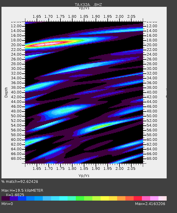
| Estimated Moho Depth: |
19.5 km |
| Estimated Crust Vp/Vs: |
1.68 |
| Assumed Crust Vp: |
6.498 km/s |
| Estimated Crust Vs: |
3.862 km/s |
| Estimated Crust Poisson's Ratio: |
0.23 |
|
| Radial Match: |
92.62426 % |
| Radial Bump: |
400 |
| Transverse Match: |
84.967545 % |
| Transverse Bump: |
400 |
| SOD ConfigId: |
424168 |
| Insert Time: |
2012-02-16 10:53:01.698 +0000 |
| GWidth: |
2.5 |
| Max Bumps: |
400 |
| Tol: |
0.001 |
|
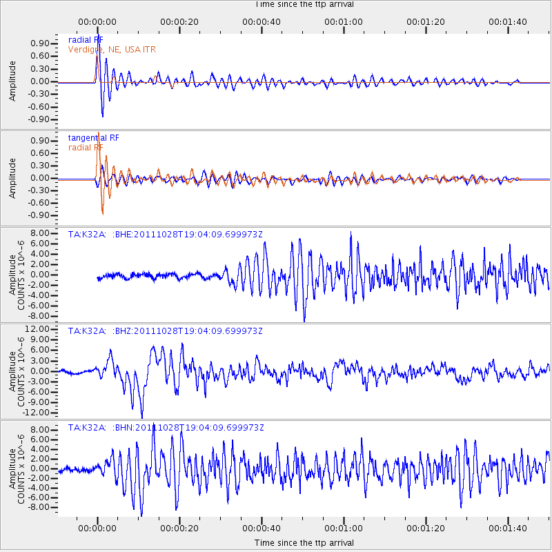
Signal To Noise
| Channel | StoN | STA | LTA |
| TA:K32A: :BHZ:20111028T19:04:09.699973Z | 6.731759 | 2.6365256E-6 | 3.9165477E-7 |
| TA:K32A: :BHN:20111028T19:04:09.699973Z | 4.4735727 | 1.7335277E-6 | 3.8750412E-7 |
| TA:K32A: :BHE:20111028T19:04:09.699973Z | 3.4566789 | 1.3638628E-6 | 3.9455873E-7 |
| Arrivals |
| Ps | 2.2 SECOND |
| PpPs | 7.7 SECOND |
| PsPs/PpSs | 9.8 SECOND |


