You are here: Home > Network List > TA - USArray Transportable Network (new EarthScope stations) Stations List
> Station I31A Royce, Wessington Springs, SD, USA > Earthquake Result Viewer
I31A Royce, Wessington Springs, SD, USA - Earthquake Result Viewer
| Earthquake location: |
Near Coast Of Peru |
| Earthquake latitude/longitude: |
-14.4/-76.0 |
| Earthquake time(UTC): |
2011/10/28 (301) 18:54:34 GMT |
| Earthquake Depth: |
24 km |
| Earthquake Magnitude: |
6.5 MB, 6.9 MS, 6.9 MW, 6.9 MW |
| Earthquake Catalog/Contributor: |
WHDF/NEIC |
|
| Network: |
TA USArray Transportable Network (new EarthScope stations) |
| Station: |
I31A Royce, Wessington Springs, SD, USA |
| Lat/Lon: |
44.03 N/98.54 W |
| Elevation: |
469 m |
|
| Distance: |
61.7 deg |
| Az: |
341.679 deg |
| Baz: |
155.026 deg |
| Ray Param: |
0.060659472 |
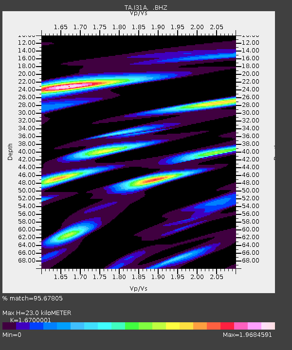
| Estimated Moho Depth: |
23.0 km |
| Estimated Crust Vp/Vs: |
1.67 |
| Assumed Crust Vp: |
6.53 km/s |
| Estimated Crust Vs: |
3.91 km/s |
| Estimated Crust Poisson's Ratio: |
0.22 |
|
| Radial Match: |
95.67805 % |
| Radial Bump: |
319 |
| Transverse Match: |
79.352936 % |
| Transverse Bump: |
400 |
| SOD ConfigId: |
424168 |
| Insert Time: |
2012-02-16 10:53:25.397 +0000 |
| GWidth: |
2.5 |
| Max Bumps: |
400 |
| Tol: |
0.001 |
|
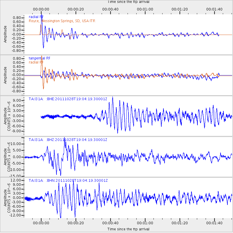
Signal To Noise
| Channel | StoN | STA | LTA |
| TA:I31A: :BHZ:20111028T19:04:19.30001Z | 10.011935 | 3.296451E-6 | 3.2925212E-7 |
| TA:I31A: :BHN:20111028T19:04:19.30001Z | 2.93566 | 1.915161E-6 | 6.5237833E-7 |
| TA:I31A: :BHE:20111028T19:04:19.30001Z | 2.3941612 | 1.2931891E-6 | 5.401429E-7 |
| Arrivals |
| Ps | 2.5 SECOND |
| PpPs | 8.9 SECOND |
| PsPs/PpSs | 11 SECOND |


