You are here: Home > Network List > TA - USArray Transportable Network (new EarthScope stations) Stations List
> Station I33A Coleman, SD, USA > Earthquake Result Viewer
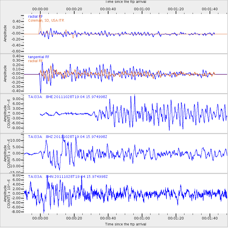
I33A Coleman, SD, USA - Earthquake Result Viewer
*The percent match for this event was below the threshold and hence no stack was calculated.
| Earthquake location: |
Near Coast Of Peru |
| Earthquake latitude/longitude: |
-14.4/-76.0 |
| Earthquake time(UTC): |
2011/10/28 (301) 18:54:34 GMT |
| Earthquake Depth: |
24 km |
| Earthquake Magnitude: |
6.5 MB, 6.9 MS, 6.9 MW, 6.9 MW |
| Earthquake Catalog/Contributor: |
WHDF/NEIC |
|
| Network: |
TA USArray Transportable Network (new EarthScope stations) |
| Station: |
I33A Coleman, SD, USA |
| Lat/Lon: |
44.05 N/96.80 W |
| Elevation: |
509 m |
|
| Distance: |
61.2 deg |
| Az: |
342.989 deg |
| Baz: |
156.854 deg |
| Ray Param: |
$rayparam |
*The percent match for this event was below the threshold and hence was not used in the summary stack. |
|
| Radial Match: |
48.517784 % |
| Radial Bump: |
400 |
| Transverse Match: |
87.05703 % |
| Transverse Bump: |
400 |
| SOD ConfigId: |
424168 |
| Insert Time: |
2012-02-16 10:54:38.628 +0000 |
| GWidth: |
2.5 |
| Max Bumps: |
400 |
| Tol: |
0.001 |
|
Signal To Noise
| Channel | StoN | STA | LTA |
| TA:I33A: :BHZ:20111028T19:04:15.974998Z | 12.180692 | 4.1984995E-6 | 3.4468482E-7 |
| TA:I33A: :BHN:20111028T19:04:15.974998Z | 3.7600393 | 3.944667E-6 | 1.0491025E-6 |
| TA:I33A: :BHE:20111028T19:04:15.974998Z | 3.179085 | 1.5211983E-6 | 4.7850193E-7 |
| Arrivals |
| Ps | |
| PpPs | |
| PsPs/PpSs | |


