You are here: Home > Network List > KN - Kyrgyz Seismic Telemetry Network Stations List
> Station TKM2 - > Earthquake Result Viewer
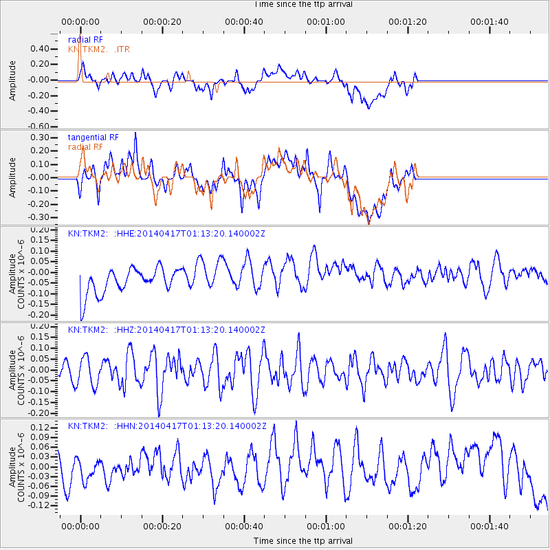
TKM2 - - Earthquake Result Viewer
*The percent match for this event was below the threshold and hence no stack was calculated.
| Earthquake location: |
W. Caroline Islands, Micronesia |
| Earthquake latitude/longitude: |
9.6/141.0 |
| Earthquake time(UTC): |
2014/04/17 (107) 01:03:07 GMT |
| Earthquake Depth: |
10 km |
| Earthquake Magnitude: |
5.3 MW |
| Earthquake Catalog/Contributor: |
ISC/ISC |
|
| Network: |
KN Kyrgyz Seismic Telemetry Network |
| Station: |
TKM2 - |
| Lat/Lon: |
42.92 N/75.60 E |
| Elevation: |
2020 m |
|
| Distance: |
65.5 deg |
| Az: |
312.791 deg |
| Baz: |
99.906 deg |
| Ray Param: |
$rayparam |
*The percent match for this event was below the threshold and hence was not used in the summary stack. |
|
| Radial Match: |
35.82717 % |
| Radial Bump: |
400 |
| Transverse Match: |
41.244747 % |
| Transverse Bump: |
400 |
| SOD ConfigId: |
3390531 |
| Insert Time: |
2019-04-11 10:35:23.846 +0000 |
| GWidth: |
2.5 |
| Max Bumps: |
400 |
| Tol: |
0.001 |
|
Signal To Noise
| Channel | StoN | STA | LTA |
| KN:TKM2: :HHZ:20140417T01:13:20.140002Z | 1.0897211 | 6.4926724E-8 | 5.9581044E-8 |
| KN:TKM2: :HHN:20140417T01:13:20.140002Z | 0.7889877 | 3.7786297E-8 | 4.7892122E-8 |
| KN:TKM2: :HHE:20140417T01:13:20.140002Z | 1.3455962 | 8.0881534E-8 | 6.010833E-8 |
| Arrivals |
| Ps | |
| PpPs | |
| PsPs/PpSs | |


