You are here: Home > Network List > TA - USArray Transportable Network (new EarthScope stations) Stations List
> Station E35A Pequot Lakes, MN, USA > Earthquake Result Viewer
E35A Pequot Lakes, MN, USA - Earthquake Result Viewer
| Earthquake location: |
Near Coast Of Peru |
| Earthquake latitude/longitude: |
-14.4/-76.0 |
| Earthquake time(UTC): |
2011/10/28 (301) 18:54:34 GMT |
| Earthquake Depth: |
24 km |
| Earthquake Magnitude: |
6.5 MB, 6.9 MS, 6.9 MW, 6.9 MW |
| Earthquake Catalog/Contributor: |
WHDF/NEIC |
|
| Network: |
TA USArray Transportable Network (new EarthScope stations) |
| Station: |
E35A Pequot Lakes, MN, USA |
| Lat/Lon: |
46.56 N/94.40 W |
| Elevation: |
409 m |
|
| Distance: |
62.9 deg |
| Az: |
345.813 deg |
| Baz: |
159.874 deg |
| Ray Param: |
0.059867106 |
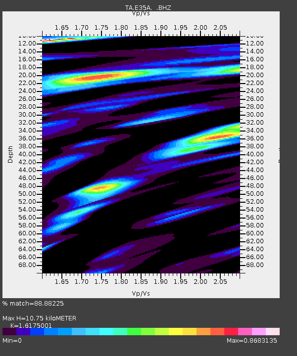
| Estimated Moho Depth: |
10.75 km |
| Estimated Crust Vp/Vs: |
1.62 |
| Assumed Crust Vp: |
6.419 km/s |
| Estimated Crust Vs: |
3.969 km/s |
| Estimated Crust Poisson's Ratio: |
0.19 |
|
| Radial Match: |
88.88225 % |
| Radial Bump: |
400 |
| Transverse Match: |
83.19729 % |
| Transverse Bump: |
400 |
| SOD ConfigId: |
424168 |
| Insert Time: |
2012-02-16 10:56:18.949 +0000 |
| GWidth: |
2.5 |
| Max Bumps: |
400 |
| Tol: |
0.001 |
|

Signal To Noise
| Channel | StoN | STA | LTA |
| TA:E35A: :BHZ:20111028T19:04:27.399985Z | 9.851774 | 4.191556E-6 | 4.2546202E-7 |
| TA:E35A: :BHN:20111028T19:04:27.399985Z | 5.086521 | 1.7091694E-6 | 3.3601935E-7 |
| TA:E35A: :BHE:20111028T19:04:27.399985Z | 2.619161 | 8.5245824E-7 | 3.2546998E-7 |
| Arrivals |
| Ps | 1.1 SECOND |
| PpPs | 4.2 SECOND |
| PsPs/PpSs | 5.3 SECOND |


