You are here: Home > Network List > TA - USArray Transportable Network (new EarthScope stations) Stations List
> Station C06D Leavenworth, WQ, USA > Earthquake Result Viewer
C06D Leavenworth, WQ, USA - Earthquake Result Viewer
| Earthquake location: |
Near Coast Of Peru |
| Earthquake latitude/longitude: |
-14.4/-76.0 |
| Earthquake time(UTC): |
2011/10/28 (301) 18:54:34 GMT |
| Earthquake Depth: |
24 km |
| Earthquake Magnitude: |
6.5 MB, 6.9 MS, 6.9 MW, 6.9 MW |
| Earthquake Catalog/Contributor: |
WHDF/NEIC |
|
| Network: |
TA USArray Transportable Network (new EarthScope stations) |
| Station: |
C06D Leavenworth, WQ, USA |
| Lat/Lon: |
47.92 N/120.89 W |
| Elevation: |
544 m |
|
| Distance: |
73.9 deg |
| Az: |
330.363 deg |
| Baz: |
134.579 deg |
| Ray Param: |
0.0526945 |
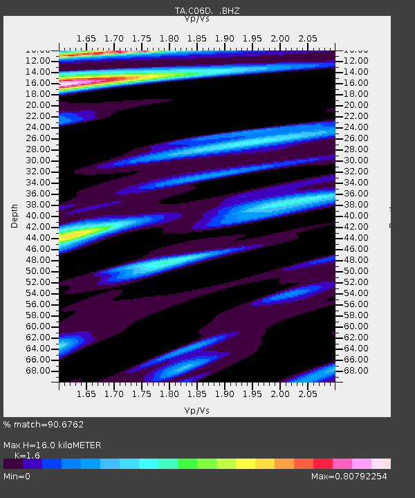
| Estimated Moho Depth: |
16.0 km |
| Estimated Crust Vp/Vs: |
1.60 |
| Assumed Crust Vp: |
6.597 km/s |
| Estimated Crust Vs: |
4.123 km/s |
| Estimated Crust Poisson's Ratio: |
0.18 |
|
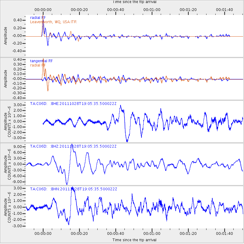
| Radial Match: |
90.6762 % |
| Radial Bump: |
343 |
| Transverse Match: |
66.45727 % |
| Transverse Bump: |
400 |
| SOD ConfigId: |
424168 |
| Insert Time: |
2012-02-16 10:56:56.231 +0000 |
| GWidth: |
2.5 |
| Max Bumps: |
400 |
| Tol: |
0.001 |
|
Signal To Noise
| Channel | StoN | STA | LTA |
| TA:C06D: :BHZ:20111028T19:05:35.500022Z | 3.0425444 | 1.0087149E-6 | 3.3153663E-7 |
| TA:C06D: :BHN:20111028T19:05:35.500022Z | 0.90453166 | 2.5097546E-7 | 2.7746455E-7 |
| TA:C06D: :BHE:20111028T19:05:35.500022Z | 0.5349009 | 2.0530263E-7 | 3.8381432E-7 |
| Arrivals |
| Ps | 1.5 SECOND |
| PpPs | 6.1 SECOND |
| PsPs/PpSs | 7.6 SECOND |


