You are here: Home > Network List > TA - USArray Transportable Network (new EarthScope stations) Stations List
> Station C34A RKJ Ranch, Bemidji, MN, USA > Earthquake Result Viewer
C34A RKJ Ranch, Bemidji, MN, USA - Earthquake Result Viewer
| Earthquake location: |
Near Coast Of Peru |
| Earthquake latitude/longitude: |
-14.4/-76.0 |
| Earthquake time(UTC): |
2011/10/28 (301) 18:54:34 GMT |
| Earthquake Depth: |
24 km |
| Earthquake Magnitude: |
6.5 MB, 6.9 MS, 6.9 MW, 6.9 MW |
| Earthquake Catalog/Contributor: |
WHDF/NEIC |
|
| Network: |
TA USArray Transportable Network (new EarthScope stations) |
| Station: |
C34A RKJ Ranch, Bemidji, MN, USA |
| Lat/Lon: |
47.65 N/94.91 W |
| Elevation: |
441 m |
|
| Distance: |
64.1 deg |
| Az: |
345.875 deg |
| Baz: |
159.532 deg |
| Ray Param: |
0.059118904 |
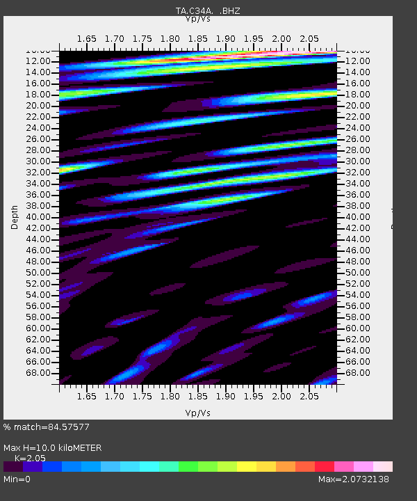
| Estimated Moho Depth: |
10.0 km |
| Estimated Crust Vp/Vs: |
2.05 |
| Assumed Crust Vp: |
6.419 km/s |
| Estimated Crust Vs: |
3.131 km/s |
| Estimated Crust Poisson's Ratio: |
0.34 |
|
| Radial Match: |
84.57577 % |
| Radial Bump: |
400 |
| Transverse Match: |
76.62241 % |
| Transverse Bump: |
400 |
| SOD ConfigId: |
424168 |
| Insert Time: |
2012-02-16 10:59:45.579 +0000 |
| GWidth: |
2.5 |
| Max Bumps: |
400 |
| Tol: |
0.001 |
|

Signal To Noise
| Channel | StoN | STA | LTA |
| TA:C34A: :BHZ:20111028T19:04:34.974998Z | 11.563036 | 3.3742808E-6 | 2.9181618E-7 |
| TA:C34A: :BHN:20111028T19:04:34.974998Z | 3.6513207 | 1.7929317E-6 | 4.9103653E-7 |
| TA:C34A: :BHE:20111028T19:04:34.974998Z | 2.0692978 | 9.92518E-7 | 4.7964E-7 |
| Arrivals |
| Ps | 1.7 SECOND |
| PpPs | 4.6 SECOND |
| PsPs/PpSs | 6.3 SECOND |


